This indicator assesses the degree to which Ontario’s protected areas system (including Dedicated Protected Areas in the Far North) has achieved ecological representation of the terrestrial landform-vegetation associations found in Ontario.
A) B)


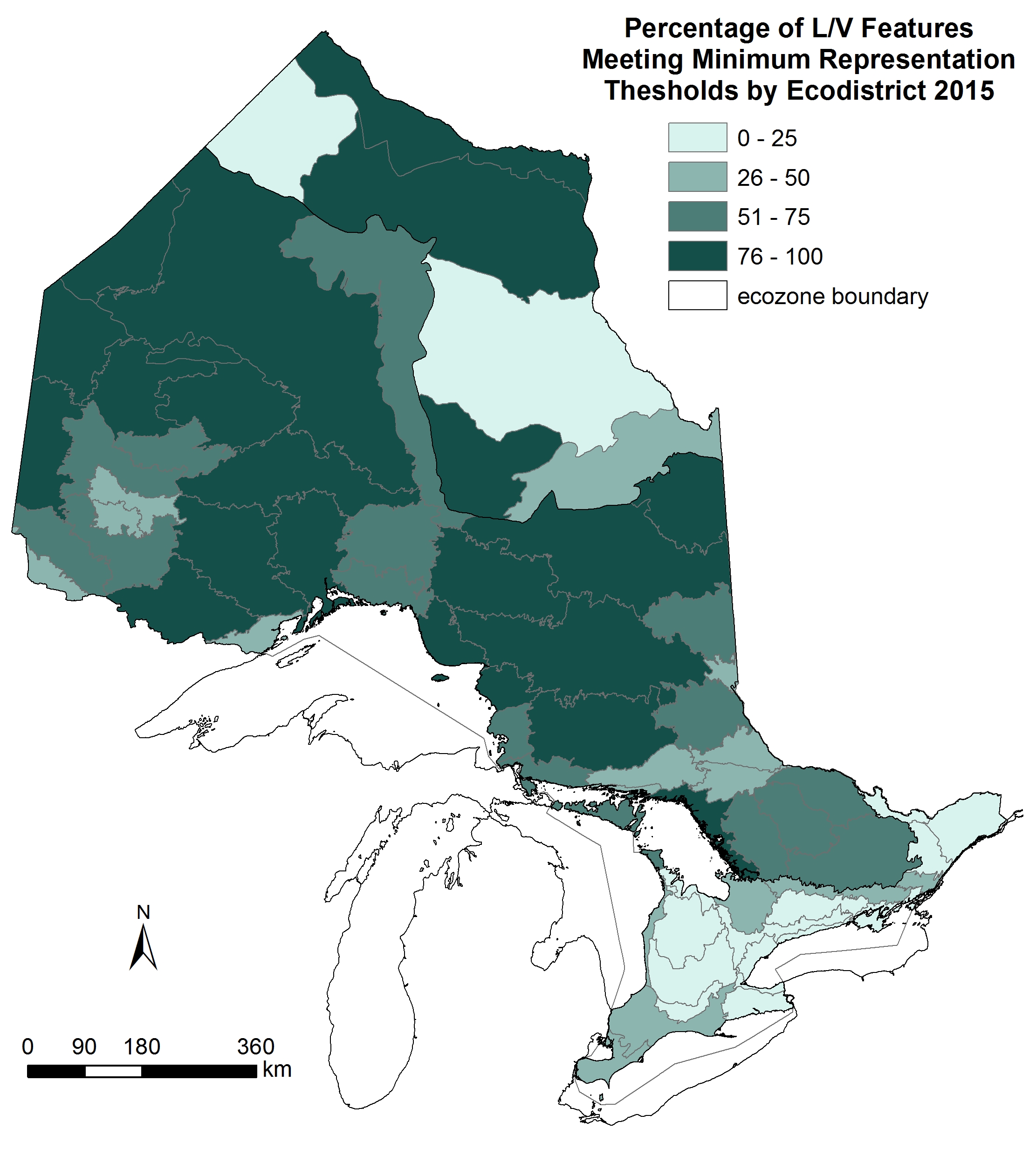
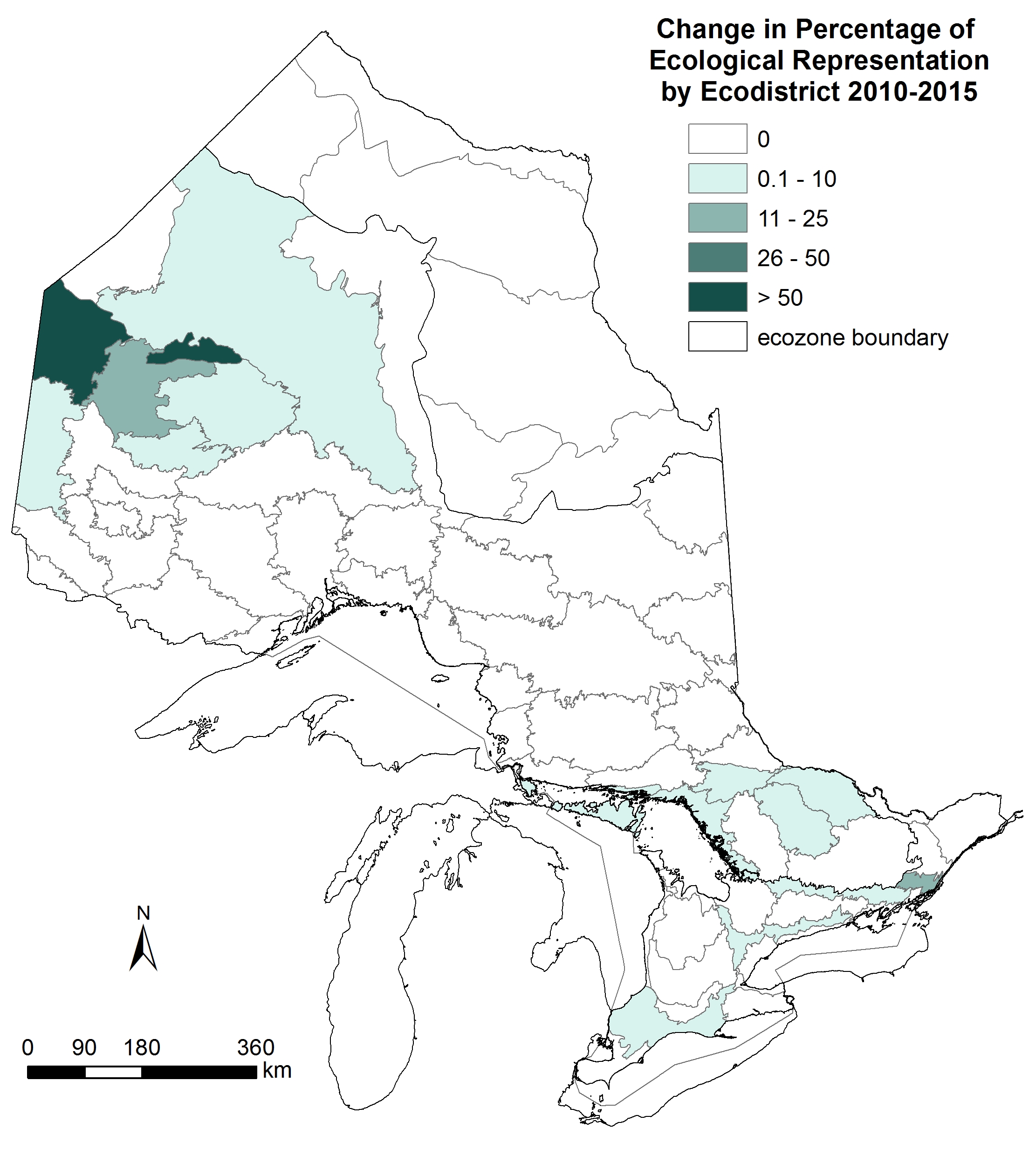
Figure 1. Representation of terrestrial life science features by ecodistrict in Ontario’s protected area system (including Dedicated Protected Areas in the Far North): A) Percentage of terrestrial landform/vegetation features meeting minimum representation thresholds in each ecodistrict as of 2015; B) Change in the percentage of ecological representation by ecodistrict between 2010 and 2015.
Status:
- Protected areas are best distributed among terrestrial natural features in the Ontario Shield Ecozone.
- Nearly all of the protected area in the Hudson Bay Lowlands Ecozone is within Polar Bear Provincial Park. The identification of additional protected areas in this ecozone (and the northern portion of the Ontario Shield Ecozone) will be accomplished in partnership with First Nations through community based land use planning as part of the Far North Land Use Planning Initiative.
- Nearly all natural features in the Mixedwood Plains are underrepresented. Most of the land in the Mixedwood Plains Ecozone is privately owned and therefore could not become regulated protected areas unless secured through acquisition or some other method; if this analysis had included privately held conservation lands, representation would be improved.
- Since 2010, there has been an increase in ecological representation achieved in 17 of Ontario’s 71 ecodistricts. The largest increases have occurred in the northwest Ontario Shield Ecozone, largely associated with the establishment of Dedicated Protected Areas in the Far North. Small increases have also occurred in several ecodistricts in the Mixedwood Plains and southern Ontario Shield ecozones.
Ecological representation was assessed by the Ontario Ministry of Natural Resources and Forestry using a GIS-based analytical tool called GapTool (Davis et al. 2006). GapTool is used to help prepare tabular reports and maps on ecological representation (including gaps in representation), based on the Ministry’s framework for representing terrestrial life science features. Minimum representation thresholds are set at 1% of the total area of the landform-vegetation type in each ecodistrict or 50 ha, whichever is greater. Including only a small portion of an ecodistrict in protected areas can often meet the minimum representation thresholds. The percentages of terrestrial landform-vegetation type area thresholds met in protected areas (including Dedicated Protected Areas in the Far North) as of 2015 were summarized by ecodistrict and mapped; changes between 2010 and 2015 were also assessed (Figure 1).
Ontario does not have an established framework for the representation of aquatic ecosystems in Ontario’s protected areas. However, some aquatic ecosystems are included in protected areas designed to represent terrestrial features, and can be protected based on criteria other than representation (i.e., ecosystem function, special features). A recent review of aquatic features for watersheds with available data showed that 6.4% of aquatic habitat was within regulated protected areas in Ontario (OMNR 2011).
It is important to note that this indicator only considers ecological representation associated with legally protected areas (provincial and federal) and Dedicated Protected Areas in the Far North. Other conservation lands held by conservation authorities, Ducks Unlimited Canada, the Nature Conservancy of Canada, Ontario Nature and Ontario land trusts contribute to ecological representation, but were not included due to the lack of comprehensive and consolidated spatial data required for GapTool analysis.
Web Links:
MNRF – Ontario’s parks and protected areas https://www.ontario.ca/environment-and-energy/ontarios-parks-and-protected-areas
References:
Davis, R., L. Chora, and W.J. Crins. 2006. GapTool: an analytical tool for ecological monitoring and conservation planning. pp. 139-150. In 2006 Parks Research Forum of Ontario Proceedings, Niagara Falls, ON.
Ontario Ministry of Natural Resources (OMNR). 2011. State of Ontario’s protected areas report. Ontario Ministry of Natural Resources, Queen’s Printer for Ontario, Peterborough, ON.


