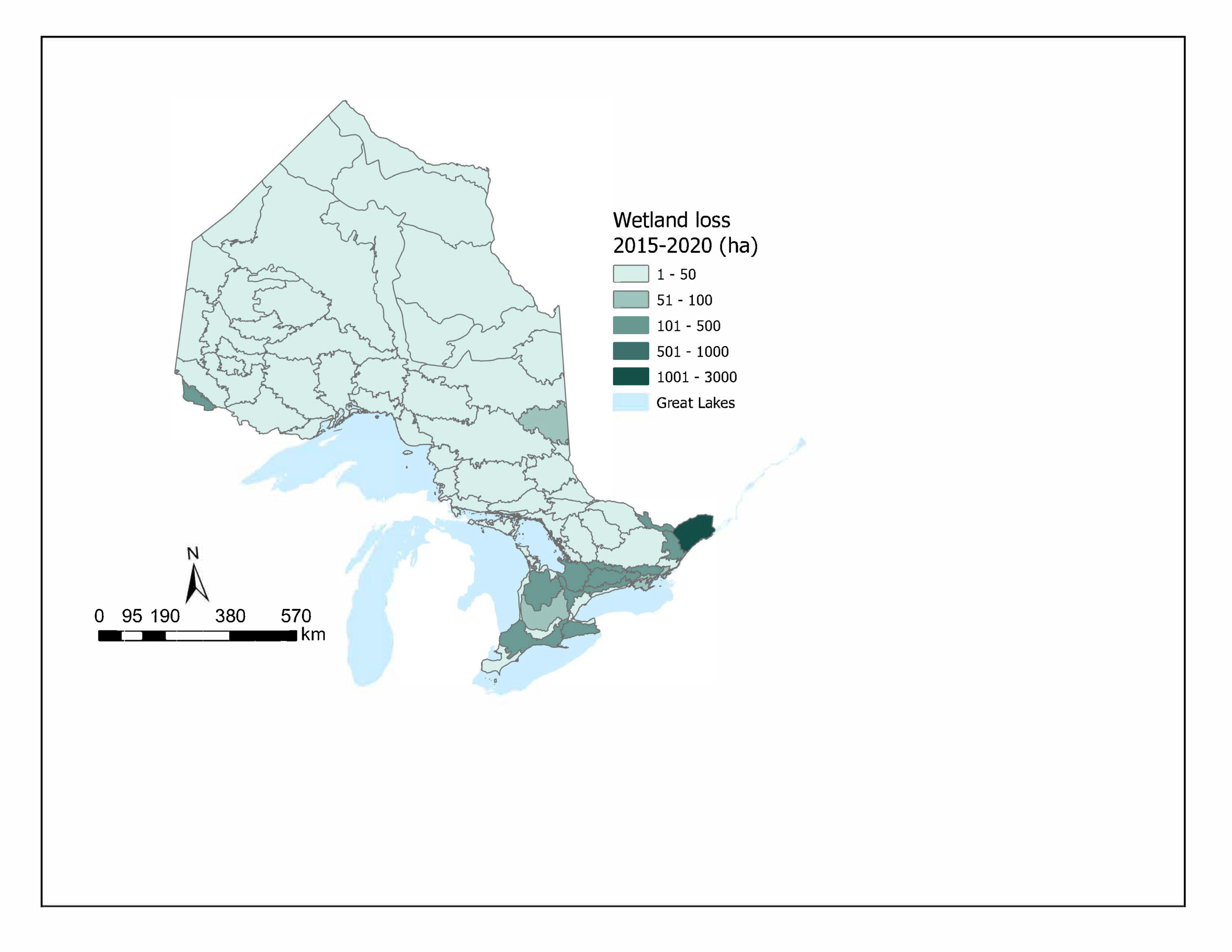
 Figure 3. Area of wetlands lost in hectares across Ontario ecodistricts over the period of 2015-2020 (OLC 2025).
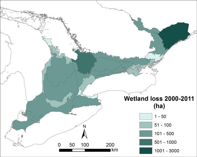
Figure 4. Area of wetlands lost in southern Ontario ecodistricts (in the Mixedwood Plains ecozone) over the period 2000-2011 as well as loss between 2011-2015 (SOLRIS 1.0 and SOLRIS 3.0).
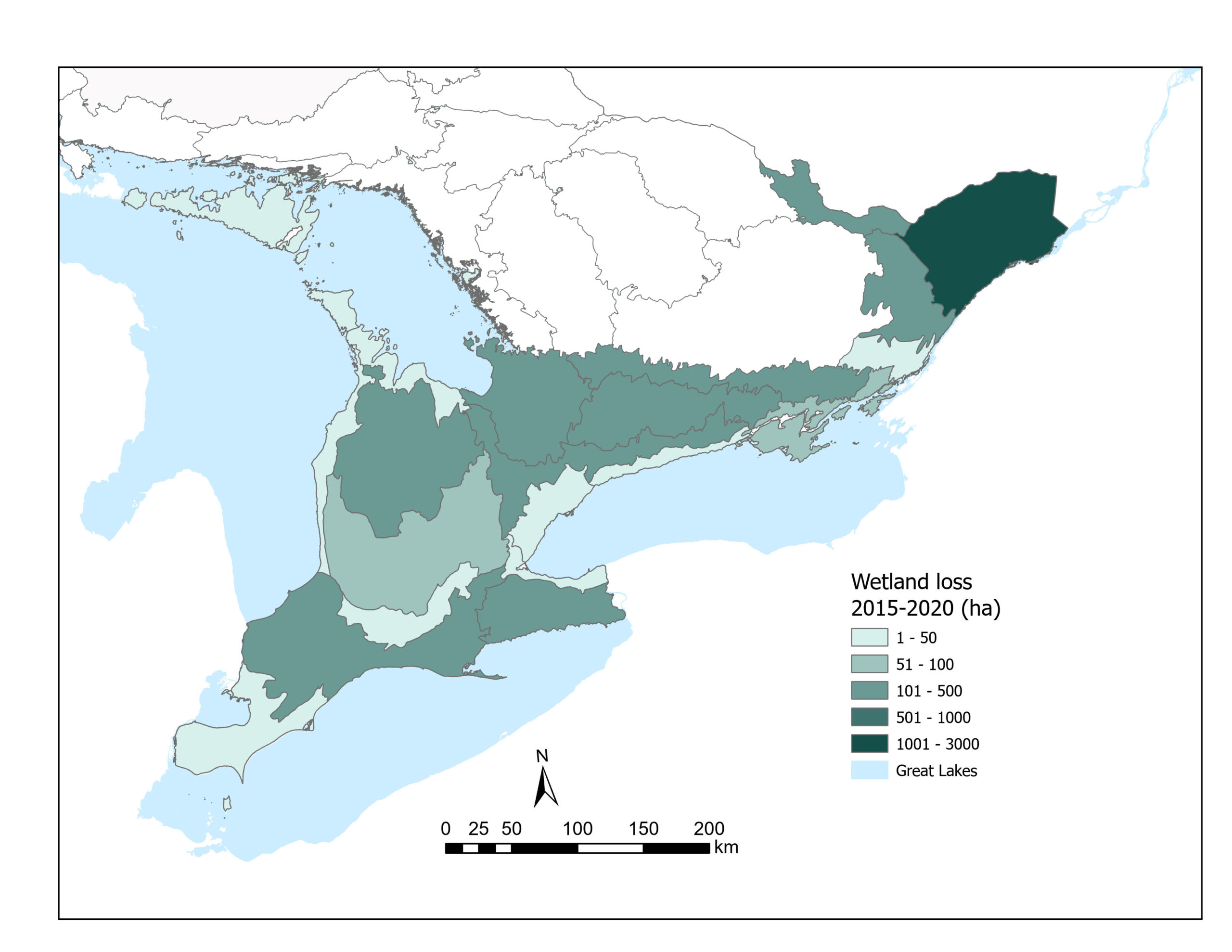
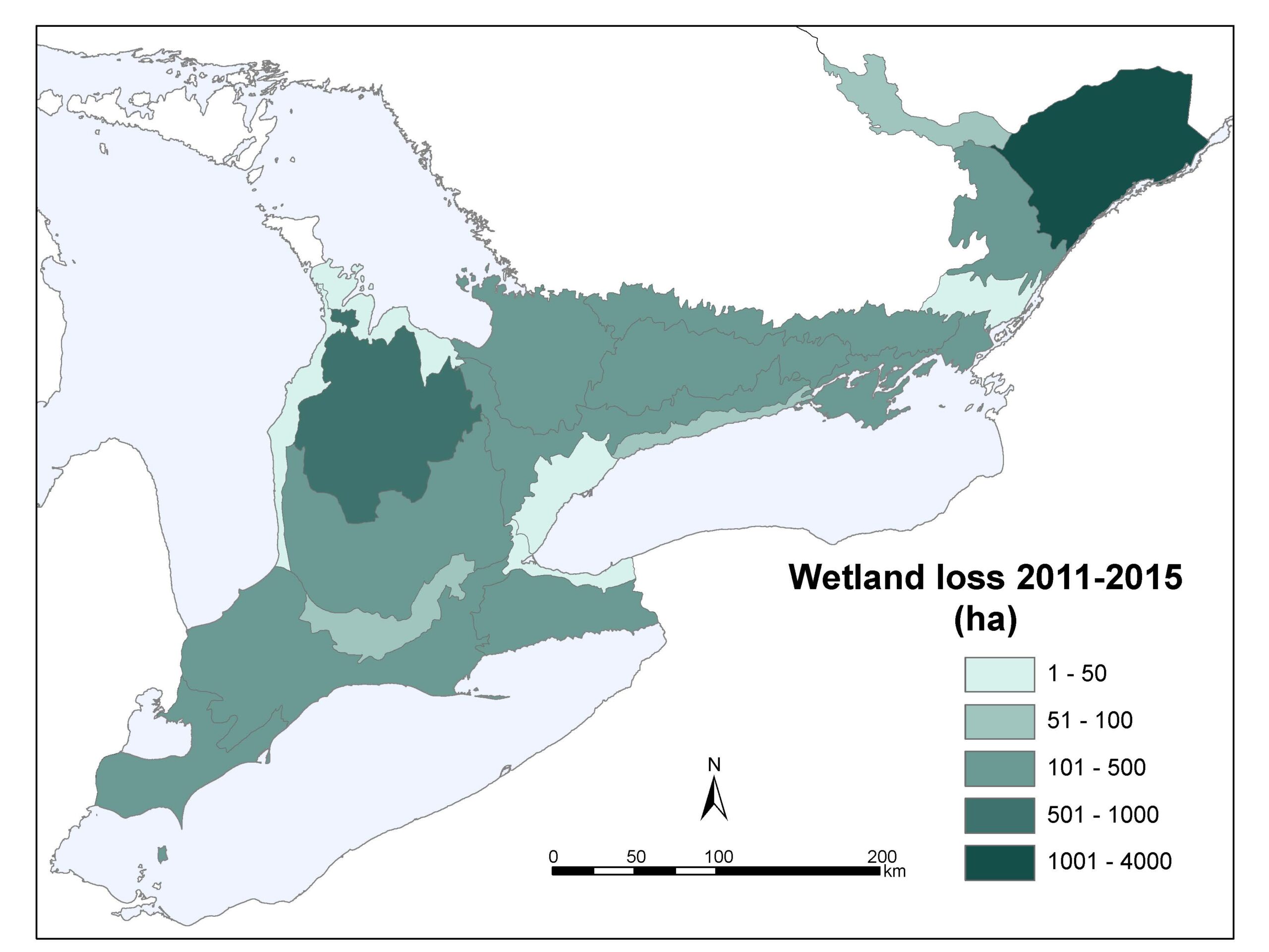
Figure 5. Area of wetlands lost in southern Ontario ecodistricts (in the Mixedwood Plains ecozone) over the period 2015-2020 (OLC 2025).
Table 1. Ecodistricts within the Mixedwood Plains ecozone with higher percentage of wetland loss in 2020 than in 2015.
| Ecodistrict (total hectares of wetland in 2020) |
Percent lost (ha lost) between 2015 and 2020 |
Percent lost between 2011 and 2015 |
| Pembroke (24148 ha) |
0.42% (103 ha) |
0.31% |
| Niagara (27789 ha) |
0.41% (115 ha) |
0.32% |
| Grimsby (2781 ha) |
0.39% (11 ha) |
0.19% |
| Oak Ridges (32479 ha) |
0.36% (118 ha) |
0.30% |
| London (12324 ha) |
0.17% (22 ha) |
0.08% |
| Havelock (85654 ha) |
0.12% (102 ha) |
0.11% |
| Tobermory (6888 ha) |
0.07% (5 ha) |
0% |
| Meaford (16332 ha) |
0.06% (9ha ) |
0.04% |
Table 2. ecodistricts with the lowest area of total wetlands ha and total hectares lost since 2015.
| Ecodistrict |
Total hectares of wetland in 2020 |
Hectares lost in 2020 (percent of wetland area lost) |
| Grimsby |
2781 ha |
11 ha (0.4%) |
| Toronto |
3492 ha |
21 ha (0.6%) |
| Tobermory |
6887 ha |
5.2 ha (0.07%) |
| La Cloche |
7035 ha |
0 ha (0%) |
| Oshawa Cobourg |
10056 ha |
35 ha (0.35%) |
| Kincardine |
10157 ha |
20 ha (0.19%) |
| London |
12324 ha |
22 ha (0.17%) |
| Meaford |
16332 ha |
9 ha (0.06%) |
| Charleston Lake |
18367 ha |
1 ha (0.006%) |
| Essex |
23181 ha |
22 ha (0.10%) |
Status
- Between 2015-2020, a total of 4,562 ha of wetlands were lost in the Mixedwood Plains ecozone, a decrease from a total of 7,303 ha between 2011 and 2015 and 6,152 ha lost between the decade of 2000 and 2011. This loss represents 0.46% of remaining wetland area in southern Ontario, a value slightly less than the 2011-2015 and the 2000–2011 assessments which represented a loss of 0.7% and 0.6% respectively.
- The Mixedwood Plains area is the ecozone with the highest amount of wetland loss at 4,562 ha, followed by the Ontario Shield with 624 ha lost and no reported loss in the Hudson Bay Lowlands.
- In 2020, similar to previous assessments, the Kemptville ecodistrict (6E-12) of eastern Ontario has lost the most amount of wetlands — a total of 2860 ha accounting for a 2% loss of wetlands in the ecodistrict — Kemptville ecodistrict has the 2nd largest amount of wetlands (114,786 ha) in the Mixedwood Plains ecozone. However, the total amount of loss within the Mixedwood Plains ecozone is 4562 ha, and therefore the amount of loss in the Kemptville ecodistrict is more than half (62%) of all the wetlands loss across the Mixedwood Plains ecozone ). In the previous assessment the Kemptville ecodistrict had the most loss of any other area with 3,913 ha (2.4% loss).
- The 2nd largest area of total wetland loss is in the Rainy River ecodistrict (5S-2) in the northwestern part of the Ontario Shield ecozone with 457 ha — 0.4% of the entire wetland area in that ecodistrict. This area has had new mining and development projects in recent years.
- Between 2015 and 2020, the total percentage of wetlands loss in 14* out of 22 ecodistricts within the Mixedwood Plains ecozone is slightly lower than in the previous assessment. However the total percentage of wetland loss for the other eight ecodistricts was higher than in the previous assessment including from highest to lowest. The total amount of hectares loss for those eight ecodistricts is 487 ha (See Table 1)
- Rate of loss in some areas of southern Ontario may be decreasing in part due to limited number of wetlands left on the landscape (see Table 2). Also, recent analysis shows that the wetlands being lost in southern Ontario are mostly small wetlands (<0.5 ha) (Birch et al. 2022).
- Wetland restoration through programs and partnerships like the Eastern Habitat Joint Venture (includes Ontario and all provinces to the East) have supported 30% of Canada’s restored wetlands (NAWMP Canada 2024).
Previous versions:
Wetlands are lands that are seasonally or permanently covered by shallow water, as well as lands where the water table is close to or at the surface. Wetlands lie at the interface of terrestrial and aquatic habitats and as a result possess a unique mixture of species, conditions and interactions. This makes wetlands among the most dynamic, biologically diverse and productive ecosystems on the planet. Wetlands provide habitat for a diverse array of species and provide a wide variety of ecosystem services that benefit people and the environment. These include shoreline stabilization, water purification, groundwater recharge and discharge, and flood control/ attenuation. Wetlands also help limit greenhouse gases in the atmosphere by acting as carbon sinks and they provide many recreational opportunities (e.g. bird watching, nature appreciation, hunting, etc). When wetlands are lost or degraded these important ecosystem services are diminished and can be challenging to replace.
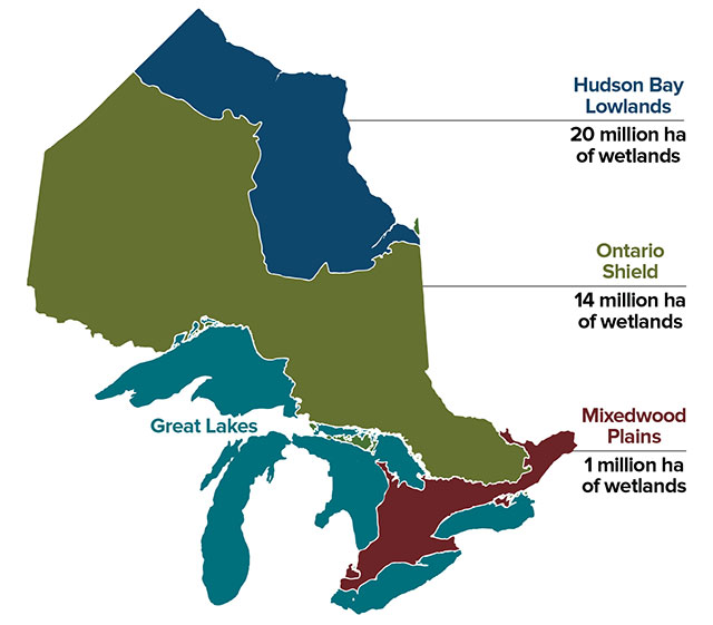
Figure 1. Ontario’s ecozones and wetland coverage (MNRF 2017).
Canada has approximately 1.29 million km² of wetlands covering 13% of the country’s terrestrial area; representing close to one quarter of the world’s remaining wetlands (ECCC 2016). Twenty-five percent of Canada’s remaining wetlands (6% of wetlands world-wide) are found in Ontario. In Ontario, four major types of wetlands are recognized: marshes, swamps, fens and bogs (OMNRF 2020). The majority of the province’s wetlands are found in northern Ontario (Figure 1). The typology and methods used to calculate wetland area in Ontario, under-represents some wetland types such as submersed vegetation wetlands. The Hudson Bay Lowlands Ecozone has more than 20,000,000 ha of wetlands that account for 82% of the ecozone and is the third largest area of wetlands in the world (Keddy et al 2009). Great Lakes coastal wetlands provide globally significant migratory bird habitat and support many globally and nationally rare species and vegetation communities.
Despite their important values, wetlands continue to be lost. It is estimated that up to 70% of wetlands have been destroyed or degraded in settled areas of Canada (DUC 2021). Wetlands in southern parts of Ontario have been and continue to be drained for agriculture, filled for development, polluted by toxic runoff and damaged by artificial changes in water levels (Environment Canada 2010). In Southern Ontario (Mixedwood Plains area), 68% of the wetlands originally present were lost by the early 1980s (OBC 2010) and an additional 4% has been lost since this time (OBC 2015). Wetland loss has been greatest in southwestern Ontario, parts of eastern Ontario, Niagara and the Toronto area, where over 85% of the original pre-settlement wetlands have been converted to other uses. While land conversion is the primary cause of wetland loss in southern Ontario, pollution, invasive species, alteration to natural water levels and climate change also pose serious threats (Environment Canada 2010).
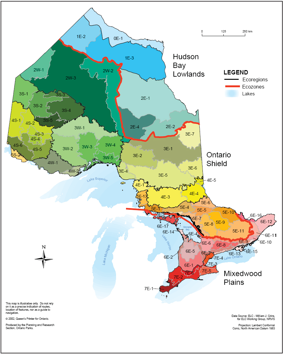
Figure 2. Ontario ecozones (red outline), ecoregions (black outline) and ecodistricts(grey outline) (MNR, 2009).
Notwithstanding some localized losses or alteration, the wetlands in the Hudson Bay Lowlands and central and northern regions of the Ontario Shield ecozones (Figure 2) are largely intact.
This indicator assesses changes in wetland extent in southern Ontario from 2000 to 2011, 2011-2015, as well as changes across Ontario between 2015-2020 based on updated land cover information.
Land cover information from the Ontario Land Cover v.1(OLC v.1) was used to assess changes in the extent of wetlands between 2015 and 2020 across the province. In previous versions of this indicator the Mixedwood Plains ecozone was the only area assessed (with the exception of Manitoulin Island) by using the Southern Ontario Land Resource Information System (SOLRIS 3.0; OMNRF 2020 in 2020 and SOLRIS 1.2 in 2015). The change analysis process provides both an updated spatial inventory and summaries of mapping class change (e.g. area of change from natural area to urban impervious).
In this application, change detection analyzes the decreases in vegetation greenness, focusing on loss, using satellite imagery for different time periods between 2000 and 2020. Changes identified during change detection were verified using orthophotography available between 2000 and 2015 as well as 2015 and 2020. The model maps large and dramatic loss well and with high certainty, but in some cases, smaller change events were not modeled with certainty, in these cases, those that occurred near high certainty events were flagged for manual review. Additional high certainty events were then identified through detailed examination of multi-date digital orthophotos. Although attempts were made to capture all major events, some remain undetected.
The total wetland area was calculated for each time period (2000-2011, 2011-2015, and 2015-2020) using a Geographic Information System (GIS). The area of wetlands lost in each ecodistrict across Ontario from 2015 to 2020 was mapped (Figure 3), as well loss in southern Ontario for the three timeframes (2000-2011, 2011-2015, and 2015-2020) (Figure 4).
Previous assessments (1982-2002) of changes in wetland cover excluded wetlands smaller than 10 ha and many Great Lakes coastal wetlands (DUC 2010). The current analysis addresses smaller wetlands but could miss the incremental loss of small areas along the edge of larger wetlands (i.e., areas less than 0.5 ha over a 5-year period). For these reasons, the results of the assessment of wetland loss since 2000 conducted for this analysis cannot be directly compared to previous assessments of loss for earlier time periods.
While this indicator assesses changes in the extent of wetland coverage, there is no comprehensive, landscape-scale data available for assessment of trends in the quality and function of remaining wetlands. The State of the Great Lakes Report 2022 indicates that coastal wetland habitats in Lake Superior and the northern shorelines of Lake Huron are generally in better condition and show fewer signs of impairment than wetlands in Lakes Erie and Ontario (ECCC and USEPA 2022).
Though not included in this indicator, wetland restoration and stewardship activities are often conducted by non-profit conservation organizations.
Download Extent of Wetland Cover and Loss 2025 summary data
Related Theme(s)
Related Target(s)
Related Themes:
Pressures on Biodiversity – Habitat Loss
Web Links:
Ducks Unlimited Canada – Ontario wetlands https://www.ducks.ca/our-work/wetlands/
Ontario Ministry of Municipal Affairs and Housing – Provincial Policy Statement, 2024 – https://www.ontario.ca/page/provincial-planning-statement-2024
Ontario Ministry of Natural Resources – wetland conservation https://www.ontario.ca/page/wetland-conservation
Environment Canada – wetlands of Ontario http://www.ec.gc.ca/tho- wlo/default. asp?lang=En&n=06269065-1
Ontario GeoHub – Southern Ontario Land Resource Information System (SOLRIS) 3.0 – https://geohub.lio.gov.on.ca/documents/lio::southern-ontario-land-resource-information- system-solris-3-0/about
The State of the Great Lakes Report 2019 (ECCC and USEPA 2021) https://binational. net/2020/06/03/sogl-edgl-2019-2/
References:
Cowardin, L. et al. 1979. Classification of Wetlands and Deepwater Habitats of the United States. US Department of the Interior Fish and Wildlife Service Office of Biological Services Washington, D.C. December 1979. Downloaded from https://www.epa.gov/sites/default/files/2017-05/documents/cowardin_1979.pdf
Cvetkovic, M., and P. Chow-Fraser. 2011. Use of ecological indicators to assess the quality of Great Lakes coastal wetlands. Ecological Indicators 11:1609-1622.
Ducks Unlimited Canada (DUC). 2006. Natural values: linking the environment to the economy – wetlands. [Available at: http://www.ducks.ca/assets/2012/06/nv6_wet.pdf]
Ducks Unlimited Canada (DUC). 2010. Southern Ontario wetland conversion analysis: final report. Ducks Unlimited Canada, Barrie, ON.
Environment Canada. 2010. Why wetlands? Environment Canada, Ottawa, ON
Environment and Climate Change Canada (2016) Canadian Environmental Sustainability Indicators: Extent of Canada’s Wetlands.
https://www.canada.ca/content/dam/eccc/migration/main/indicateurs-indicators/69e2d25b- 52a2-451e-ad87-257fb13711b9/4.0.b-20wetlands_en.pdf
Environment and Climate Change Canada and the U.S. Environmental Protection Agency. 2021. State of the Great Lakes 2019 Technical Report. Cat No. En161- 3/1E-PDF. EPA 905-R-20-044. [Available at www.binational.net]
Environment and Climate Change Canada and the U.S. Environmental Protection Agency. 2022. State of the Great Lakes 2022 Technical Report. Cat No. En161-3/1E-PDF. EPA 905-R22-004. Available at binational.net.
Keddy, PA, Fraser, LH, Solomeshch, AI, Junk, WJ, Campbell, DR, Arroyo, MTK, et al. 2009. Wet and Wonderful: The World’s Largest Wetlands Are Conservation Priorities. BioScience, 59(1), 39-5 Natural Resources Canada. 2011. Polarimetric RADARSAT-2 for monitoring Canadian wetlands.
Natural Resources Canada, Ottawa, ON. [Available at: http://www.nrcan.gc.ca/sites/www.nrcan. gc.ca/files/earthsciences/pdf/sarrso/pdf/polarimet_e.pdf]
National Wetland Management Plan, Canadian Habitat Matters, 2024. [Available at: https://nawmp.wetlandnetwork.ca/Media/Content/files/Habitat%20Matters%202024%20Annual%20Report.pdf]
Ontario Biodiversity Council (OBC). 2010. State of Ontario’s biodiversity 2010. A report of the Ontario Biodiversity Council, Peterborough, ON. [Available at: http://www. ontariobiodiversitycouncil.ca/index.php/reports]
Ontario Biodiversity Council. 2021. State of Ontario’s Biodiversity 2020: Summary. A report of the Ontario Biodiversity Council, Peterborough, ON.
Ontario Ministry of Municipal Affairs and Housing – Provincial Policy Statement, 2020. [Available at: https://www.ontario.ca/page/provincial-policy-statement-2020]
Ontario Ministry of Natural Resources and Forestry (OMNR). 2019. Southern Ontario Land Resource Information System Version 3.0 – Ontario Ministry of Natural Resources and Forestry, Peterborough, ON.
Ontario Ministry of Natural Resources 2025. Ontario Land Cover version 1.0 – Ontario Ministry of Natural Resources, Peterborough, ON.
Ontario Ministry of Natural Resources and Forestry (OMNRF). 2017. A Wetland Conservation Strategy for Ontario 2017-2030. [Available at: https://www.ontario.ca/page/wetland-conservation-strategy]
Story prepared by Nature Conservancy of Canada staff. Between 1800 and 2011, over 1.4 million hectares (about 55%) of wetlands in southern Ontario were lost. In some parts of the province, these losses were even more dramatic: Essex County in Ontario’s far southwest lost about 92% of its wetlands in this time, while Haldimand-Norfolk lost about 82%. Most of these losses were due to drainage for agriculture, development and transportation. Today, we can see that the impacts of these losses are …
Read More