This indicator assesses trends in the number of Municipal Official Plans that identify natural heritage systems or associated features and areas, and include policies to protect them.

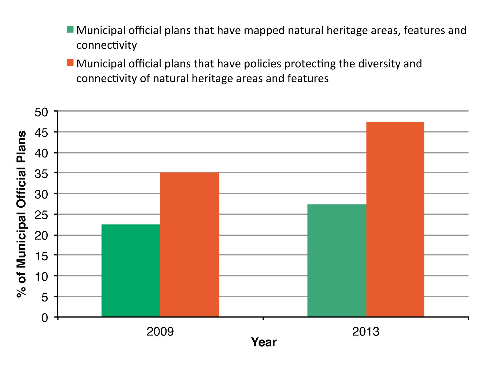
Figure 1. Change in the number of Municipal Official Plans that identify natural heritage features and areas, and incorporate related policy into to their Municipal Official Plans.
Status:
- The percentage of Municipal Official Plans that formally identify and protect natural heritage features and connectivity is low (< 50%).
- Between 2009 and 2013 the percentage of Municipal Official Plans that had mapped natural heritage features and areas and identified existing and potential linkages increased slightly from 22.5% to 27.5%.
- Between 2009 and 2013 the percentage of Municipal Official Plans that had policies protecting the diversity and connectivity of natural heritage features and areas increased from 35% to 47.5%.
This indicator was adapted from the Provincial Policy Statement, 2005: Performance Monitoring Framework and Indicator Results (OMMAH 2014). Data for this indicator were obtained by reviewing a representative cross-section of 40 Municipal Official plans selected from all areas of Ontario. A range of single-tier, upper-tier and lower tier municipalities, as well as planning boards in northern Ontario, were included in the analysis. Care was taken to ensure that large, small, urban and rural municipalities from all regions of the province were also included in the analysis. To capture changes in Municipal Official Plans, the same sample was used in both 2009 and 2013.
Data for this indicator reflect direction provided in the Provincial Policy Statement, 2005. The Provincial Policy Statement was updated in 2014 following extensive public review. The revised Provincial Policy Statement now requires identification of natural heritage systems in the Mixedwood Plains Ecozone (ecoregions 6E and 7E).
Criteria for determining whether a municipality had policies that formally identified and protected natural heritage systems was necessarily broad, as prior to 2014, municipalities in Ontario were not required to identify and protect in policy natural heritage systems. As such, municipal official plans vary in how they identify and protect natural heritage systems.
Web Links:
Provincial Policy Statement, 2005: Performance Monitoring Framework and Indicator Results http://www.mah.gov.on.ca/Page9100.aspx
Provincial Policy Statement 2014 http://www.mah.gov.on.ca/Page10679.aspx
References:
Johnson, A.E., and M.W. Klemens. 2005. The impacts of sprawl on biodiversity. In E.A. Johnson and M.W. Klemens (Eds). Nature in fragments: the legacy of sprawl. Columbia University Press, New York.
Ontario Ministry of Municipal Affairs and Housing (OMMAH). 2005. Provincial Policy Statement. Queen’s Printer for Ontario, Toronto, ON. [Available: http://www.mah.gov.on.ca/Page1485.aspx]
Ontario Ministry of Municipal Affairs and Housing (OMMAH). 2014. Provincial Policy Statement. Queen’s Printer for Ontario, Toronto. [Available: http://www.mah.gov.on.ca/Page10679.aspx]
Ontario Ministry of Municipal Affairs and Housing, Provincial Planning Policy Branch (OMMAH). 2014. Provincial Policy Statement, 2005: performance monitoring framework and indicator results. Queen’s Printer for Ontario, Toronto, ON. [Available: http://www.mah.gov.on.ca/Page9100.aspx]
It’s a sight you don’t see every day: cattail marshes, Green Herons, Painted Turtles, Wood Ducks, Mallards and the occasional Osprey…right beside new subdivisions. Yet these all coexist in the town of Aurora, Ontario, where the municipality is working to balance development with the need for urban biodiversity including wildlife habitat. Bolstered by two major land donations (to Ducks Unlimited Canada and the Oak Ridges Moraine Land Trust) and the identification of a natural heritage syste…
Read More

