This indicator assesses changes in the length of roads in both southern and northern Ontario based on the Ontario Road Map and the Ontario Road Network as an index of habitat loss and landscape fragmentation.
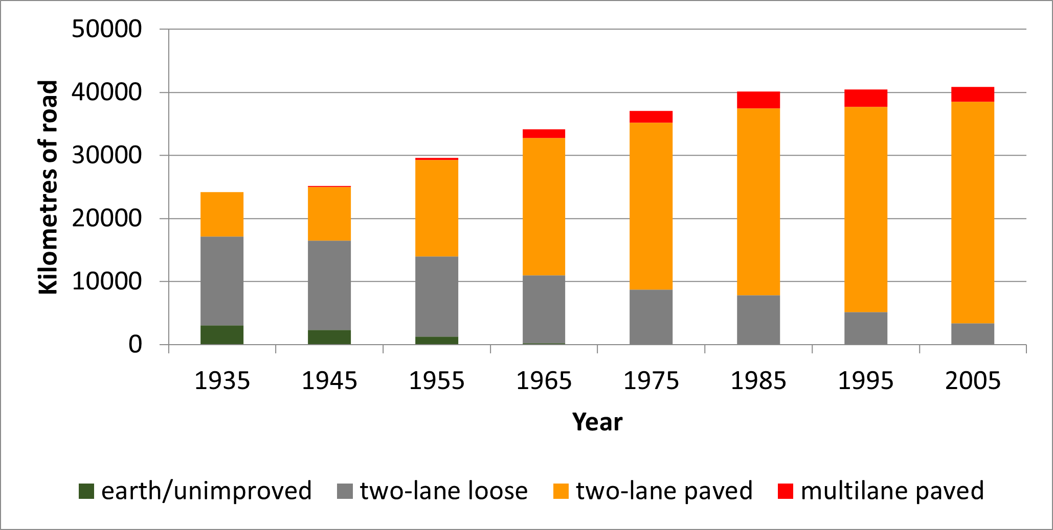
 Figure 1. Road lengths in southern Ontario by road class, based on the Ontario Road Map (ORM), 1935-2005. Does not include municipal roads or Northern Ontario roads.

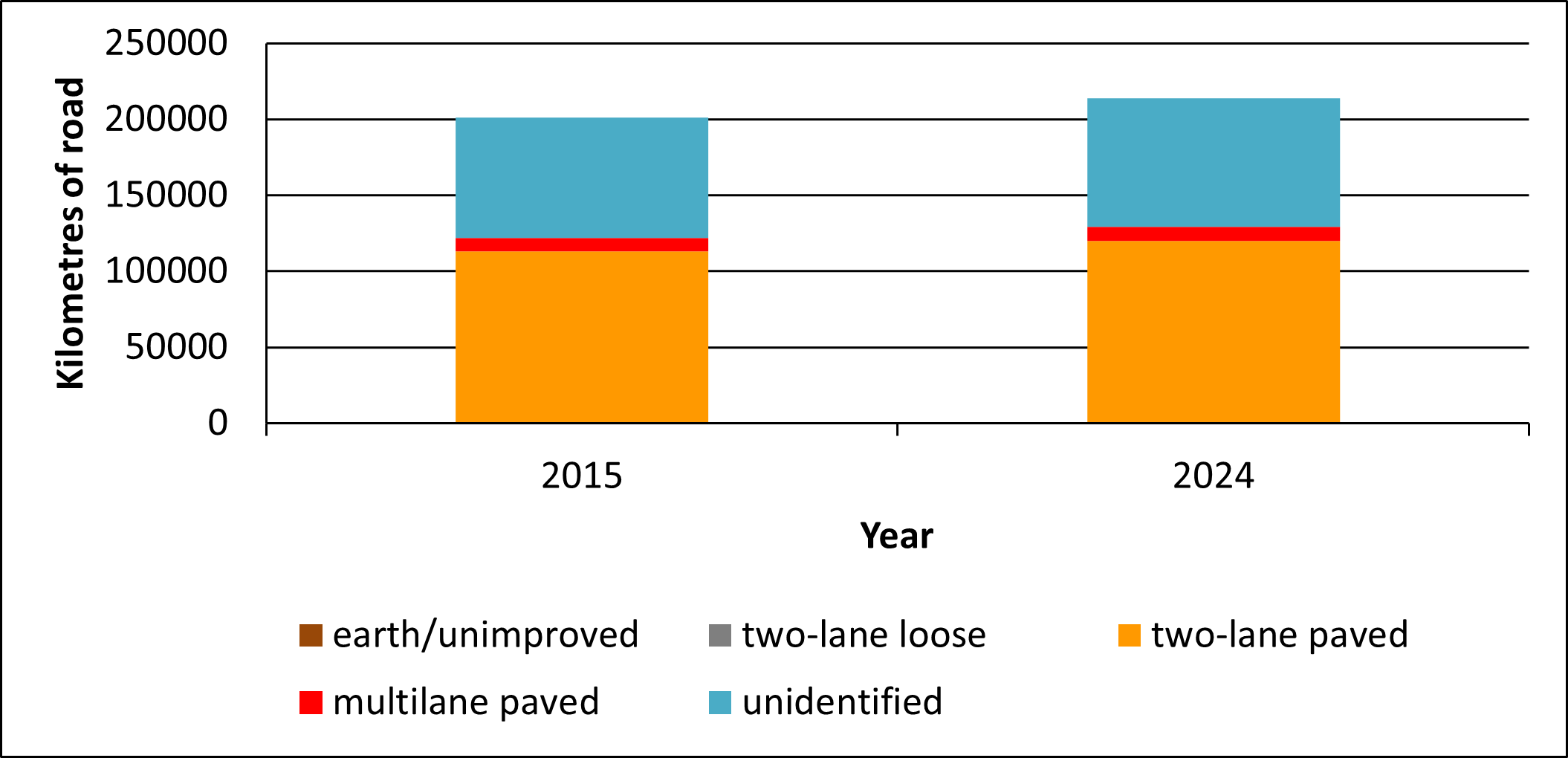
Figure 2. Ontario road lengths in kilometres by road class based on the Ontario Road Network (ORN) 2015 – 2024 — including northern Ontario and municipal roads.
Table 2. Road lengths by kilometre and road class in Ontario based on the Ontario Road Map 1935-2005 — excluding northern Ontario and municipal roads (ORM).
| Year |
Multilane paved |
Two-lane paved |
Two-lane loose |
Earth/ unimproved |
Total km of change |
| 1935 |
0 |
7,083 |
14,108 |
3,031 |
24,222 |
| 1945 |
118 |
8,558 |
14,101 |
2,367 |
25,145 |
| 1955 |
333 |
15,254 |
12,725 |
1,270 |
29,582 |
| 1965 |
1,312 |
21,783 |
10,817 |
199 |
34,112 |
| 1975 |
1,837 |
26,481 |
8,756 |
0 |
37,074 |
| 1985 |
2,668 |
29,639 |
1,840 |
0 |
40,147 |
| 1995 |
2,765 |
32,521 |
5,156 |
0 |
40,442 |
| 2005 |
2,285 |
35,148 |
3,402 |
0 |
40,836 |

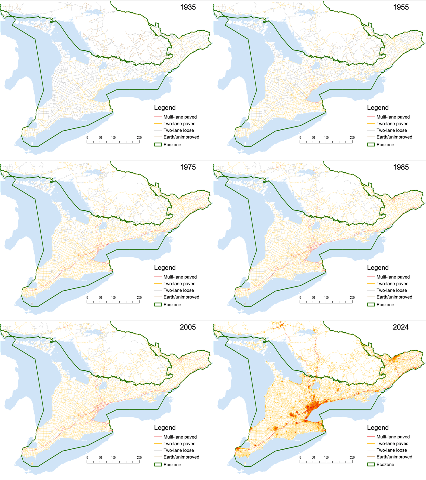
Figure 3. Major road changes in southern Ontario based on the Ontario Road Map (1935-2005) and the Ontario Road Network (2015-2024).
Table 3. Ontario Road length by kilometre and road class based on the Ontario Road Network 2015-2024 — including Northern Ontario and municipal roads. Roads unable to be classified due to missing data are included in unidentified (ORN).
| Year |
Multilane paved |
Two-lane paved |
Two-lane loose |
Earth/ unimproved |
Unidentified |
Total km of change |
| 2015 |
8,862 |
113,092 |
148 |
15 |
79,088 |
201,205 |
| 2024 |
9,317 |
119,917 |
152 |
16 |
84,498 |
213,900 |

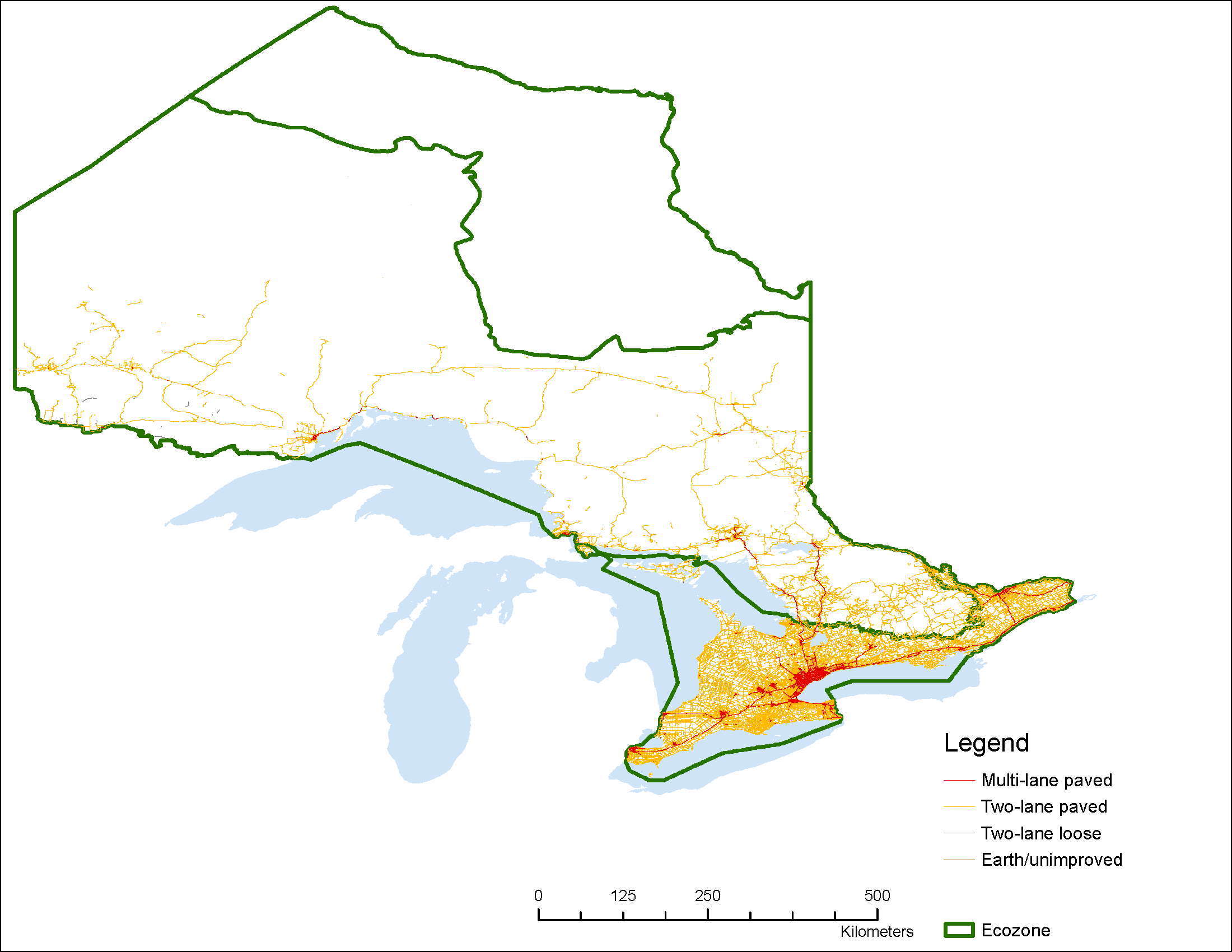
Figure 4 . Roads in Ontario (2024) based on the Ontario Road Network. Roads classified as “unidentified” are not included.
Status:
- Based on the Ontario Road Map (ORM), the length of roads in southern Ontario increased from 24,200 km in 1935 to 40,800 km in 2005, representing an increase of 69% (ORM – excluding Northern Ontario and municipal roads).
- The average rate of increase between 1935 and 2005 in southern Ontario was approximately 7% per 10-year interval.
- Based on the Ontario Road Network (ORN), the length of roads in Ontario increased from 201,205 km in 2015 to 213,900 km in 2024, representing an increase of 6% (12, 695 km) (ORN – including northern Ontario and municipal roads). This 10-year interval rate of increase (6%) is on track with the average 10-year rate between 1935 to 2005 (7%).
- Although the rate of increase in total road length slowed after 1985 (> 2% increase between 1985 and 2005), the total length of paved roads in southern Ontario increased from 7,000 km in 1935 to 37,400 km in 2005, including 2,300 km of multi-lane paved roads that did not exist in 1935.
Previous version: Road length in Ontario – 2015
Habitat loss from land degradation and fragmentation is recognized as one of the greatest threats to biodiversity and roads represent a major form of landscape modification. Globally, paved road lengths are projected to increase by 25 million kilometres by 2050, with nine tenths of all road construction occurring within least developed and developing countries (IPBES 2023). Roads are a ubiquitous feature of human-modified landscapes and Ontario is no exception, contributing to habitat loss by fragmenting ecosystems, disrupting wildlife movement, and degrading natural environments. Globally and in Ontario, healthy and intact road-free natural areas are decreasing, reducing biodiversity and ecosystem resilience to environmental and climatic changes.
Ontario has a high density of roads, with the southern portion of the province having some of the highest density of roads in the country. Major roads in southern Ontario increased fivefold from 1935 to 1995 (OBC 2010) and have continued to grow since, though the rate of growth has slowed (OBC 2015). Additionally, traffic volumes on Ontario roads have increased since the 1980s (OTMO, 2010), and the number of road motor vehicles registered in Ontario is up 22 per cent from a decade ago (statistics Canada data, 2024), an increase of over 2 million vehicles. It is predicted that Ontario’s population will increase by 43.6 per cent — from 15.1 million people in 2017 to 21.7 million people by 2046 — with the largest growth predicted in the GTA and fastest growth in central Ontario (Ontario Ministry of Finance, 2023), adding pressure not only to Ontario’s built infrastructure and roads but also the surrounding nature and biodiversity.
Building new roads encourages more development by providing access to untapped resources and driving land colonization, habitat disruption, and further road network expansion (Johnson et al., 2020; Laurance et al., 2014). The environmental impacts of roads are numerous, and their proliferation typically leads to negative impacts on biodiversity. Plant, insect, herptile, bird and mammal richness and community composition have all been shown to be affected by roads (Coffin 2007). Biodiversity loss may occur directly via road-kill events (Jaeger et al. 2005), disturbance or pollution (Sanzo and Hecnar 2006; Warren et al. 2006), or indirectly by stimulating and facilitating loss of habitat, and forming barriers to dispersal and gene flow (Jaeger et al. 2005; Keller and Largiader 2009). Roads may also affect biodiversity through reduction in habitat quality, facilitating human access to less developed landscapes, increasing the risk of the introduction of invasive species, increasing the risk of forest fires and the creation of edge effects at road-habitat boundaries (Forman and Alexander 1998; Gelbard and Belnap 2003; Jaeger et al. 2005; Fahrig and Rytwinski 2009).
The consideration of environmental impacts when roads are constructed or upgraded in Ontario has improved in recent decades. The Environmental Assessment Act sets up a thorough process for assessing the environmental impacts of various alternatives for road development prior to government approvals. This helps to protect the natural environment and mitigate the environmental impacts.
Two methods were used to summarize road lengths, based on the data and analysis methods available in different time periods. In the 2015 indicator report the Ontario’s Ministry of Transportation’s Ontario Road Map (ORM) was used, maps were digitized and summarized, providing an overview of changes from 1935-2005.
The current report is using the Ontario Ministry of Natural Resources’ Ontario Road Network (ORN) dataset, to compare change from 2015 to 2020.
Though using two different datasets means direct comparisons between the two SOBR reports is not possible, this change is necessary to address data limitations of scale in the ORM¹. The ORN will be used to report on the road length indicator in this report and moving forward.
For the 2015 report, the length of road in four different classes (earth/unimproved, two-lane loose, two-lane paved, multilane paved – see Table 1) in southern Ontario was assessed in ten-year intervals beginning in 1935 to 2005 based on the ORM. The ORM’s southern Ontario Road data was digitized and summarized by Fenech et al. (2000) by decade from 1935 to 1995, and data from 2005 was digitized by the Ontario Ministry of Natural Resources and Forestry.
In this current report, using the ORN, assessments of the 2015 and 2024 data were completed by measuring the length of roads in five categories. This included Northern Ontario roads, municipal roads and roads classed as unidentified (Table 1). Thousands of kilometers of municipal and other roads were added with the change from the ORM to ORN (Figure 4).
Road lengths were measured, and changes were analyzed and compared for each decade from 1935 to 2005 (Figure 1 and Table 2) and 2015-2024² (Figure 2 and Table 3).
Table 1. Road classes and associated descriptions used to categorize roads in ORM and ORN.
| Road class |
Description |
| Earth/unimproved |
Roads with surface identified as ‘dirt’, and pavement status ‘unpaved’. |
| Two-lane loose |
Roads with surface identified as ‘gravel’, pavement status ‘unpaved’ and number of lanes equal 2. |
| Two-lane paved |
Roads with pavement status identified as ‘paved’ and number of lanes equal to 2. |
| Multi-lane paved |
Roads with pavement status identified as ‘paved’ and number of lanes equal to or greater than 4. |
| Unidentified (ORN only) |
Roads that could not be categorized due to missing data. |
¹Due to limitations of scale, the ORM assessments do not include all roads within the province. The ORM includes about 20% of the roads mapped within the ORN (OMNRF, 2014).
² Road data for 2025 was not available at the time of publication and will be added once available.
Related Theme(s)
Related Target(s)
References:
Climate Risk Institute. (2023). Ontario Provincial Climate Impact Assessment Technical Report. Report prepared by the Climate Risk Institute, Dillon Consulting, ESSA Technologies Ltd., Kennedy Consulting and Seton Stiebert for the Ontario Ministry of Environment, Conservation and Parks. Available at: https://www.ontario.ca/page/ontario-provincial-climate-change-impact-assessment
Coffin, A.W. 2007. From roadkill to road ecology: a review of the ecological effects of roads. Journal of Transportation Geography 15:396–406.
Fahrig, L., and T. Rytwinski. 2009. Effects of roads on animal abundance: An empirical review and synthesis. Ecology and Society 14:21-41.
Fenech, A., B. Taylor, R. Hansell, and G. Whitelaw. 2000. Major road changes in southern Ontario 1935-1995: Implications for protected areas. University of Toronto, Integrated Mapping Assessment Project, Toronto, ON.
Forman, R.T.T., and L.E. Alexander. 1998. Roads and their major ecological effects. Annual Review of Ecology, Evolution, and Systematics 29:207–231.
Gelbard, J. L. and J. Belnap. 2003. Roads as conduits for exotic plant invasions in semiarid landscape. Conservation Biology 17:420–432.
Geneletti, D. 2003. Biodiversity impact assessment of roads: and approach based on ecosystem rarity, Environmental Impact Assessment Review, Volume 23, Issue 3. 343-365 https://www.sciencedirect.com/science/article/abs/pii/S0195925502000999
Hartgen,D.T., C.g. Chadwick, and M.G. Fields. 2008. Transportation Performance of the Canadian Provinces. www.fraserinstitute.org/sites/default/files/TransportationPerformancePart1.pdf
Jaeger, J.A.G, J. Bowman, J. Brennan, L. Fahrig, D. Bert, J. Bouchard, N. Charbonneau, K. Frank, B. Gruber, and K. Tluk von Toschanowitz. 2005. Predicting when animal populations are at risk from roads: an interactive model of road avoidance behavior. Ecological Modelling 185:329–348.
Keller, I., and C.R. Largiader. 2003. Recent habitat fragmentation caused by major roads leads to reduction of gene flow and loss of genetic variability in ground beetles. Proc. R. Soc. London. B 270:417–423.
Ontario Biodiversity Council (OBC). 2010. State of Ontario’s biodiversity 2010. A report of the Ontario Biodiversity Council, Peterborough, ON.
Ontario Biodiversity Council. 2015. State of Ontario’s Biodiversity [web application]. Ontario Biodiversity Council, Peterborough, Ontario. [Available at: http://ontariobiodiversitycouncil.ca/sobr (Date Accessed: December 20, 2023)].
Ontario Biodiversity Council. 2020. State of Ontario’s Biodiversity [web application]. Ontario Biodiversity Council, Peterborough, Ontario. [Available at: http://ontariobiodiversitycouncil.ca/sobr (Date Accessed: December 20, 2023)].
Ontario Ministry of Finance (Mof) Ontario populations projections 2022-2046. [web application]. Available at https://www.ontario.ca/page/ontario-population-projections [Date accessed: June 4, 2024]
Ontario Ministry of Natural Resources (OMNR). 2009. Landscape fragmentation analysis, data inputs and assumptions report for the ecosystem status and trends report for the Mixedwood Plains. Ontario Ministry of Natural Resources, Peterborough, ON.
Ontario Ministry of Natural Resources and Forestry. 2024. User guide for ORN road net element LIO data class. Ontario Ministry of Natural Resources and Forestry, Queen’s Printer for Ontario, Toronto, ON.
Ontario Ministry of Transportation (OMTO). 2010. Provincial highway traffic volumes 1988-2010. Ontario Ministry of Transportation, Toronto, ON.
Ontario Ministry of Natural Resources and Forestry. 2014. User guide for ORN road net element LIO data class. Ontario Ministry of Natural Resources and Forestry, Queen’s Printer for Ontario, Toronto, ON.
One of the most important impacts of roads on wildlife populations is the direct mortality of animals as they are hit and killed by vehicles. In Ontario alone, there are approximately 14,000 wildlife/vehicle collisions reported each year (almost all involving large herbivores such as deer). There are many more unreported collisions involving smaller mammals, birds, reptiles and amphibians (Ontario Road Ecology Group 2010). For instance, over a 5-month study period, more than 24,000 vehicle-verte…
Read More
 Figure 1. Road lengths in southern Ontario by road class, based on the Ontario Road Map (ORM), 1935-2005. Does not include municipal roads or Northern Ontario roads.


