This indicator includes information on the distribution and numbers of medium and large dams to assess the degree to which Ontario’s aquatic ecosystems are fragmented by engineered barriers. Consideration of aquatic connectivity is incomplete without considering road crossings as potential barriers. Therefore this indicator also includes information on the numbers and distribution of road crossings.
A) B)


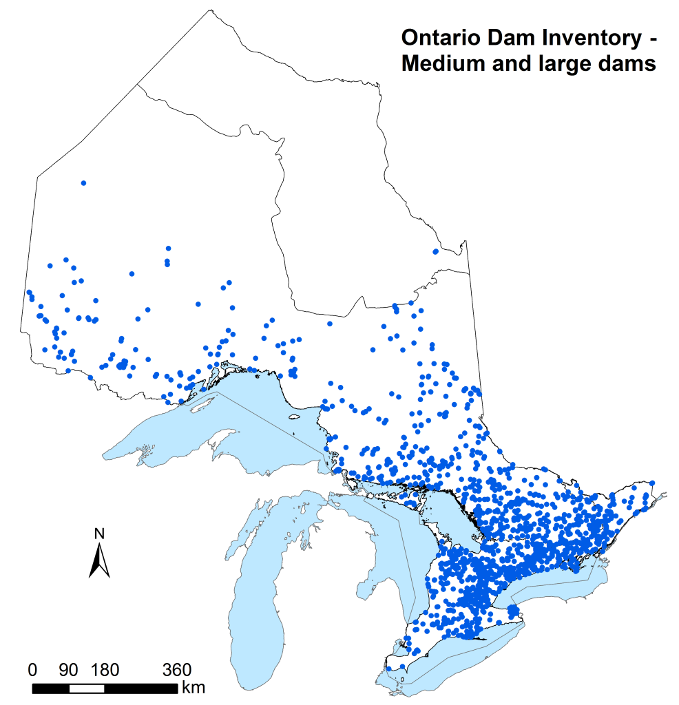
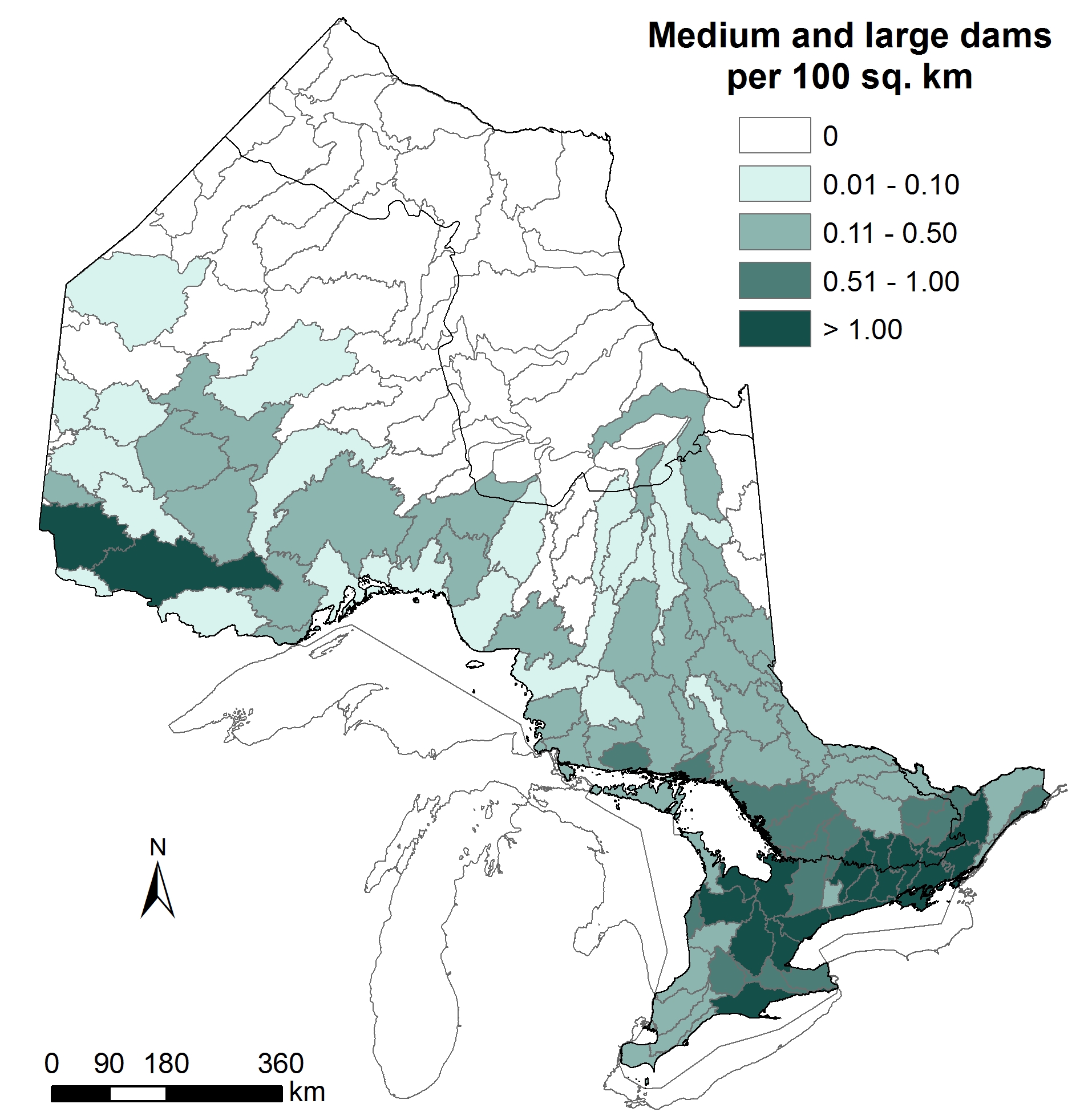
Figure 1. A) Location of medium and large dams in Ontario; B) Number of medium and large dams per 100 square km by tertiary watershed in Ontario (Ontario Dam Inventory 2014).

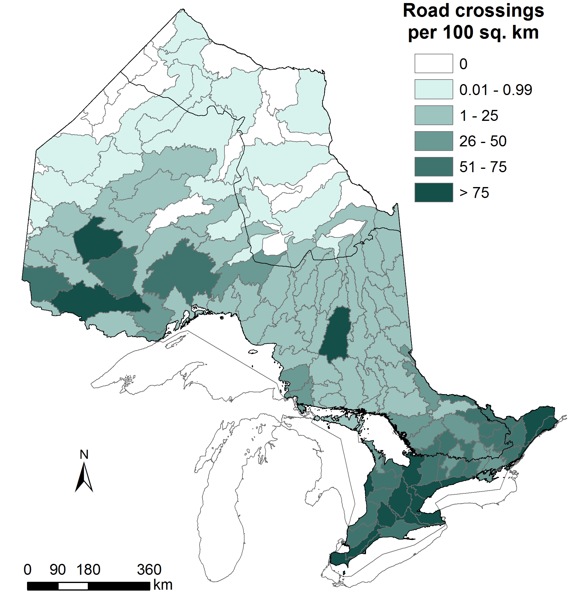
Figure 2: Number of road crossings per 100 km^2 by tertiary watershed.
Figure 2. Number of road crossings per 100 square km by tertiary watershed.
Status:
- A total of 1,596 medium and large dams have been identified in Ontario. The density of medium and large dams is highest in the watersheds of the Mixedwood Plains Ecozone and the southern Ontario Shield Ecozone.
- There are no medium and large dams in most tertiary watersheds in the Hudson Bay Lowlands Ecozone and some watersheds in the northern portion of the Ontario Shield Ecozone.
- There are more than 120,000 road crossings of streams in Ontario. The highest densities of crossings tend to be in the Mixedwood Plains Ecozone, but most of the Ontario Shield Ecozone also has significant densities of stream crossings.
- The majority of road crossings are on smaller streams where culverts are often used instead of bridges (78% of crossings are on 1st and 2nd order streams). Culverts can act as barriers to the movement of aquatic species. The number of culverts that act as barriers to aquatic species is unknown.
Dams can provide several benefits including renewable hydroelectric power generation, flood control, the creation of wetlands and recreational opportunities associated with reservoirs. However, they can also negatively affect aquatic biodiversity. Dams interrupt the flow of streams and can alter the natural variation in the size, duration, timing, frequency and variability in flows (Poff and Hart 2002; Helfman 2007). Upstream areas are often flooded, changing habitats into warmer, more lake-like conditions, and the habitat in downstream channels is sometimes changed by alterations to flow, erosion and sediment deposition. Dams also fragment aquatic habitats preventing migratory species from accessing important habitats and interrupting gene flow between local subpopulations. Sometimes dams can act as beneficial barriers that stop some invasive species from reaching upstream habitats. However, there is also evidence that dams can facilitate the establishment of invasive species (Johnson et al. 2008). Although the impacts of large dams have received much attention, the cumulative impacts of multiple small dams that exist on the tributaries of many watersheds can also be significant (Helfman 2007; Stanfield 2012, Mahlum et al. 2014).
In the first State of Ontario’s Biodiversity Report (Ontario Biodiversity Council 2010), this indicator was included, but was ranked as ‘not assessed’ because information on the location and number of dams in Ontario had not been assembled and verified. A spatial dataset of Ontario’s medium and large dams is now available allowing the development of this indicator (Ontario Dam Inventory). The dataset includes 1,596 dams, 40 of which were identified as having a fishway designed to allow upstream movement of at least some fish species. Dams included in the Ontario Dam Inventory were determined through visual inspection of orthophotography. The medium and large dams identified in the database are those on larger systems and those that appeared to have an impact on water flow. Small dams on small creeks and ditches are more numerous (at least 2,000 in Ontario), but have not been incorporated into the database.
This indicator includes information on the distribution and numbers of medium and large dams to assess the degree to which Ontario’s aquatic ecosystems are fragmented by engineered barriers. Consideration of aquatic connectivity is incomplete without considering road crossings as potential barriers (Januchowski-Hartley et al. 2013). Therefore this indicator also includes information on the numbers and distribution of road crossings. Bridges usually have no effect on connectivity, but culverts can sometimes become perched and impassable to fishes and other aquatic species, and can act as a barrier similar to dams. Unfortunately it is not possible to determine the passability of road crossings without doing site inspections. Case studies of four American watersheds in the Great Lakes basin revealed that 13 to 58% of road crossings per watershed were barriers for a range of native fish species (Januchowski-Hartley et al. 2013). There is also ongoing work to inventory culverts that are perched above the water level at the downstream end and therefore also increase fragmentation in Ontario’s watersheds (Stanfield, 2013). Where these have been inventoried, they result in significant increases in measures of fragmentation and have been shown to be correlated with altered fish assemblages (Stanfield, 2012, Mahlum et al. 2014). In the Greater Toronto Area, 11% of Etobicoke Creek road crossings and 13% of Mimico Creek road crossings assessed were barriers to fish passage (TRCA 2010). In the Rouge River watershed, 31% of 806 in-stream structures assessed were barriers and most of these were perched culverts (TRCA and OMNR 2010). Twenty-three percent of 1,171 culverts assessed in 17 Lake Ontario watersheds were perched (Chau and Lancaster 2012).
While the number of dams is unlikely to change quickly, many dams are nearing the end of their life cycle and mitigation projects that may include installation of fish passage structures or dam removal and habitat restoration are being considered for several dams within the Great Lakes basin (EC and USEPA 2014). Field assessments of stream crossings and other potential in stream barriers can be used in conjunction with network analysis to determine priority sites for enhancing aquatic connectivity (Cote at al. 2009; Januchowski-Hartley et al. 2013).
The locations of medium and large dams in the Ontario Dam Inventory were mapped at the provincial scale using GIS software (Figure 1). The dam locations were overlaid with the boundaries of Ontario’s tertiary watersheds to determine the density of medium and large dams in each watershed (Figure 1). The location of road crossings on streams was determined using GIS software by intersecting the Ontario Road Network (excluding winter roads) with the Ontario Hydro Network. The density of crossings in each watershed was then determined by overlaying tertiary watershed boundaries (Figure 2).
Spatial data used to develop this indicator (Ontario Dam Inventory, Ontario Road Network, Ontario Hydro Network, Watershed Tertiary) are available through the Land Information Ontario (LIO) web site – https://www.javacoeapp.lrc.gov.on.ca/geonetwork/srv/en/main.home.
Related Target(s)
Web Links:
SOLEC 2011 [Aquatic Habitat Connectivity – p. 34] http://binational.net/wp-content/uploads/2014/11/sogl-2011-technical-report-en.pdf
References:
Environment Canada and the United States Environmental Protection Agency (EC and USEPA). 2014. State of the Great Lakes 2011. Cat No. En161-3/1-2011E-PDF. EPA 950-R-13-002. [Available at: http://binational.net/wp-content/uploads/2014/11/sogl-2011-technical-report-en.pdf]
Cote, D., D.G Kehler, C. Bourne, and Y.F. Wiersma. 2009. A new measure of longitudinal connectivity for stream networks. Landscape Ecology 24:101-113.
Chau, J., and P. Lancaster. 2012. Going with the flow: an analysis of Check Your Watershed Day data, 2006 to 2010. EcoSpark, Toronto, ON. [Available at: http://www.ecospark.ca/sites/default/files/mtm/CYWD_comm_report.pdf]
Helfman, G. 2007. Fish conservation: a guide to understanding and restoring global aquatic biodiversity and fishery resources. Island Press, Washington, DC.
Januchowski-Hartley, S.R., P.B. McIntyre, M. Diebel, P.J. Doran, D. Infante, C. Joseph, and J.D. Allan. 2013. Restoring aquatic ecosystem connectivity requires expanding inventories of both dams and road crossings. Frontiers in Ecology and the Environment 11:211-217.
Johnson, P.T.J., J.D. Olden, and M.J. Vander Zanden. 2008. Dam invaders: impoundments facilitate biological invasions in freshwaters. Frontiers in Ecology and the Environment 6:357-363.
Mahlum, S., D. Kehler, D. Cote, Y.F. Wiersma, and L. Stanfield. 2014. Assessing the biological relevance of aquatic connectivity to stream fish communities. Canadian Journal of Fisheries and Aquatic Sciences 71:1852-1863.
Ontario Biodiversity Council (OBC). 2010. State of Ontario’s Biodiversity 2010. A report of the Ontario Biodiversity Council, Peterborough, ON. [Available at https://sobr.ca/wp-content/uploads/SOBR-2010_Highlights-Report_E.pdf]
Poff, N.L., and D.D. Hart. 2002. How dams vary and why it matters for the emerging science of dam removal. BioScience 52:659-668.
Stanfield, L.W., I. Kelsey, R. Sitch, and A. Skinner. 2013. S4.M9. Instream crossing and barrier attribution. In Stanfield, L. W. (Ed.). 2013. Stream assessment protocol for southern Ontario, v 9.0. Ontario Ministry of Natural Resources. Peterborough, ON.
Toronto and Region Conservation Authority (TRCA). 2010. Etobicoke and Mimico Creeks watersheds technical update report, Toronto and Region Conservation Authority, Toronto, ON. [Available at: http://www.trca.on.ca/dotAsset/148577.pdf]
Toronto and Region Conservation Authority and Ontario Ministry of Natural Resources (TRCA and OMNR). 2010. Rouge River watershed fisheries management plan – draft, December 2010. Toronto and Region Conservation Authority and Ontario Ministry of Natural Resources, Toronto, ON. [Available at: http://trca.on.ca/dotAsset/101866.pdf]
In 2008, Lake Simcoe Region Conservation Authority (LSRCA) researchers identified a good candidate site for aquatic habitat restoration where Western Creek and the East Holland River meet in the centre of Newmarket. Issues at the site included unstable banks, lack of vegetation and an in-stream fish barrier. LSRCA, in partnership with the Town of Newmarket, the Regional Municipality of York, the Lake Simcoe Conservation Foundation (LSCF) and Royal Bank’s Blue Water Fund, raised the resources n…
Read More


