
The Far North of Ontario is a vast, largely wilderness region stretching from Manitoba to James Bay and from approximately 50 degrees north latitude to Hudson Bay as defined by the Far North Act, 2010. This immense landscape encompasses 42% of Ontario’s landmass spanning 451,808 km² of boreal forest and wetland; and is home to one of the world’s most southerly tundra ecosystems. It is made up of two ecologically distinct regions, the Hudson Bay Lowlands and the Ontario Shield, each with their unique diversity of land forms and living resources. Ontario’s Far North Act sets out four guiding objectives: 1. a significant role for First Nations in planning; 2. the protection of areas of cultural value and the protection of ecological systems by including at least 225,000 km² in an interconnected network of protected areas designated in community based land use plans; 3. the maintenance of biological diversity, ecological processes and ecological functions, including the storage and sequestration of carbon; and 4. enabling sustainable economic development that benefits First Nations. In support of community based land use planning and other Far North Act objectives, the Ontario of Ministry of Natural Resources and Forestry initiated an Information and Knowledge Management Plan targeting such topics as hydrology, land cover, peat land studies, surficial geography and biodiversity.
The Far North Biodiversity Project (FNBP) seeks to provide a foundation of information on the terrestrial living resources in support of community based land use planning. The project has the general goal of providing life science information at multiple spatial scales across Ontario’s Far North. At the broader scale it will provide information on the occurrence of selected terrestrial biodiversity components (birds, mammals, reptiles and amphibians, invertebrates, and plants) across community planning areas. It will also provide similar biodiversity information on specific areas (finer scales) of high natural heritage value which may be considered for some level of protection through land use planning exercises. The project is an inventory of species occurrence and, in some cases abundance, utilizing a wide variety of terrestrial field data collection protocols and some small fish sampling.
Between 2009 and 2014 the project has surveyed approximately 400 sites across much of the Far North (Figure 1). Field crews used standardized methodologies and expert guided searches to identify approximately 1721 individual flora and fauna species (see Table 1). Specimens are still being identified and electronic data interpreted so these values represent preliminary finds. In addition to many range extensions within Ontario, the project also found 83 species not previously reported in the province (Table 1).
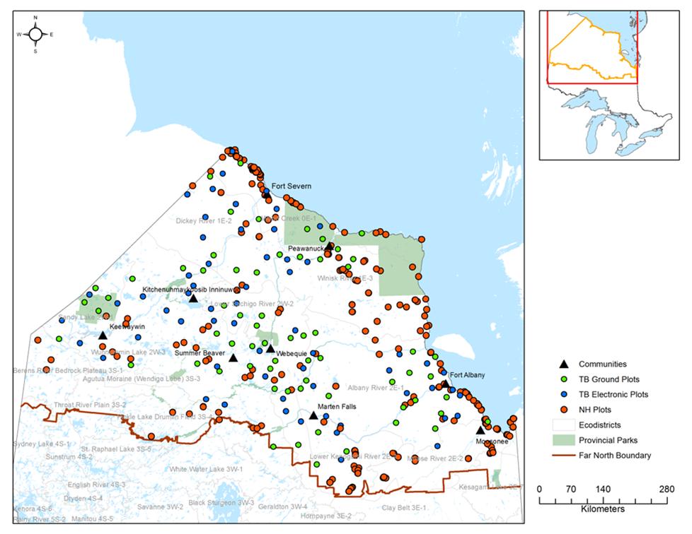
Figure 1. Locations visited by the Far North Biodiversity Project between 2009 and 2014.
Figure 1. Locations visited by the Far North Biodiversity Project between 2009 and 2014.
Table 1. Species numbers detected and the number of species previously not reported in Ontario, as discovered by the Far Biodiversity Project from 2009 to 2014. These numbers are still preliminary as identifications are ongoing.
| Taxonomic group | Species detected | New species detected; not previously reported in Ontario |
| Lichen and Lichenicolous Fungi | 310 | 35 |
| Bryophytes | 272 | 23 |
| Vascular Plants | 846 | 10 |
| Horse and Deer Flies | 30 | 1 |
| Mosquitoes | 19 | 2 |
| Dragonflies | 61 | 1 |
| Butterflies | 54 | 0 |
| Spiders | 141 | 9 |
| Leeches | 3 | 1 |
| Molluscs | 77 | 1 |
| Fishes | 26 | 0 |
| Amphibians | 7 | 0 |
| Reptiles | 1 | 0 |
| Birds | 150 | 0 |
| Mammals | 34 | 0 |
| Total | 1721 | 83 |
Products from this project include mapped distributions of rare species and species of interest to First Nations. Frog species, for example, were identified as a group of interest during a recent presentation in Fort Severn by community elders because of the changes to species being heard recently in comparison to the past. Project staff continue to support MNRF Far North planners in making this information available to First Nations. Additionally new finds are being published as appropriate to ensure results are widely discoverable into the future.
The project team would like to acknowledge the kind support of the First Nations communities for hosting the project, and the dedicated work of field crews and experts working on identifications.
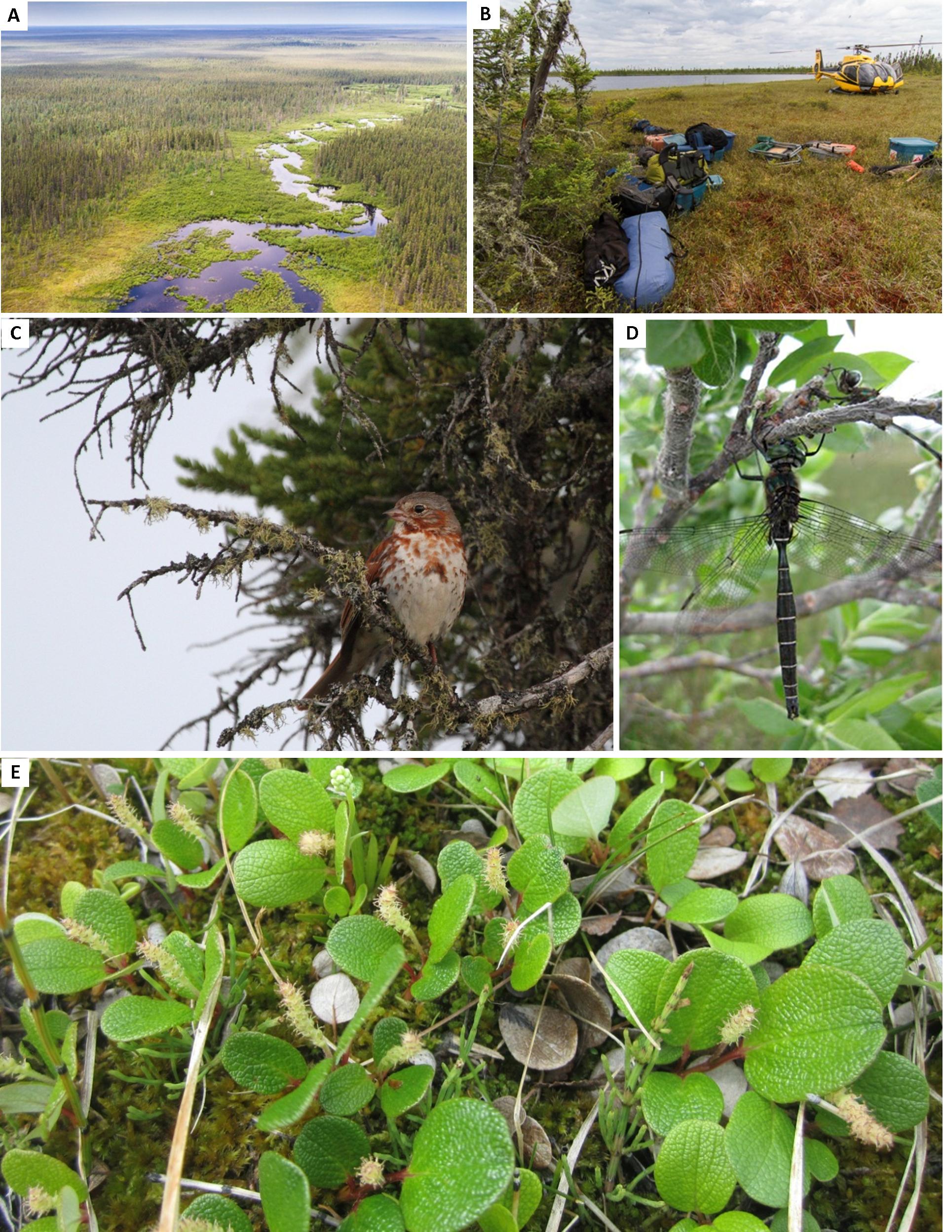
Figure 2. A) Ontario’s Far North; a matrix of many intact ecosystems (Timothy Irvin, MNRF); B) Unloading survey equipment ready to begin work north of Marten Falls (Timothy Irvin, MNRF); C) A Fox Sparrow (Passerella iliaca) observed near Fort Severn; one of 150 bird species detected (David McGeachy, MNRF); D) A Hudsonian Emerald (Somatochlora hudsonica). Not recorded since 1940, rediscovered near Moosonee in 2009 (Colin Jones, MNRF); and, E) Net-veined Willow (Salix reticulata); photographed near Fort Severn (Michael McMurtry, MNRF).
Figure 2. A) Ontario’s Far North; a matrix of many intact ecosystems (Timothy Irvin, MNRF); B) Unloading survey equipment ready to begin work north of Marten Falls (Timothy Irvin, MNRF); C) A Fox Sparrow (Passerella iliaca) observed near Fort Severn; one of 150 bird species detected (David McGeachy, MNRF); D) A Hudsonian Emerald (Somatochlora hudsonica). Not recorded since 1940, rediscovered near Moosonee in 2009 (Colin Jones, MNRF); and, E) Net-veined Willow (Salix reticulata); photographed near Fort Severn (Michael McMurtry, MNRF).