
Figure 2. Total area of alvar, dune, prairie/savannah and Great Lakes coastal meadow marsh ecosystems in Ontario showing the amount of each type that is protected in 2025. (source: NHIC database, MNR, 2025).
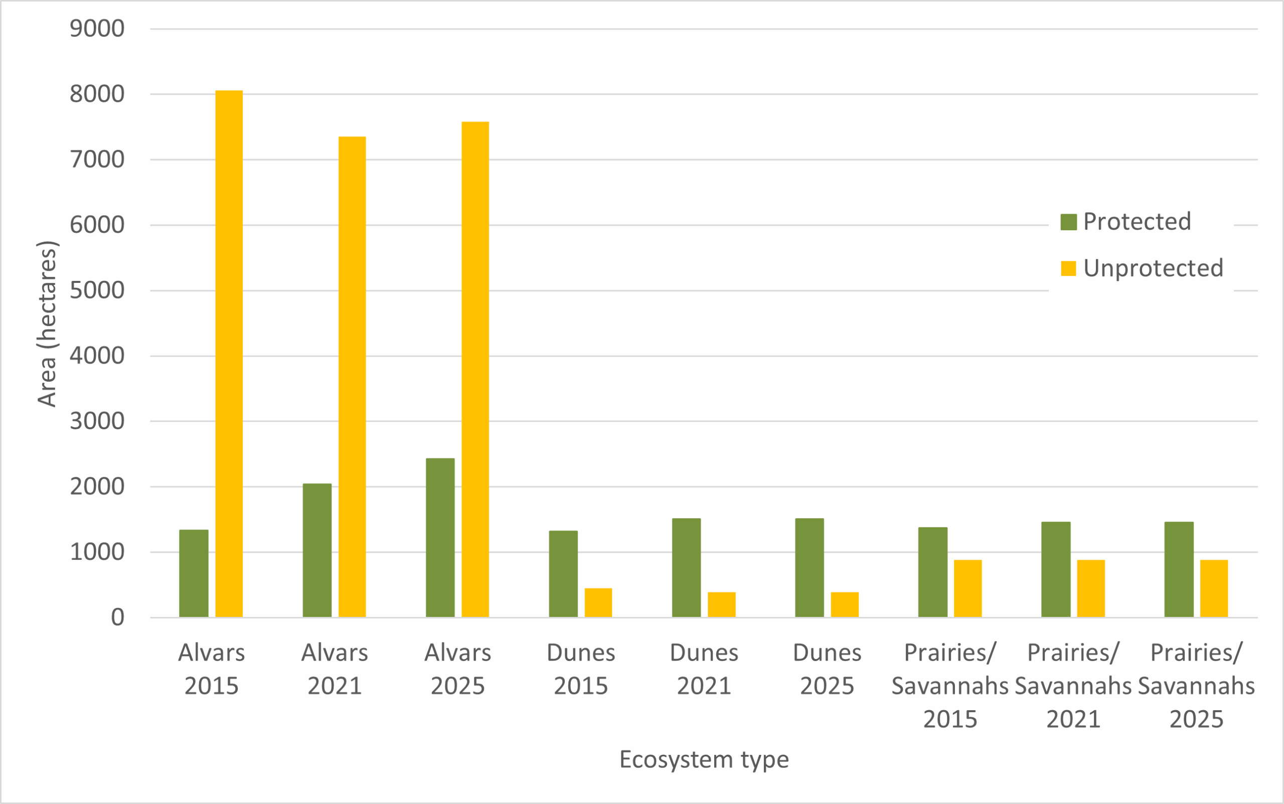
Figure 3. Total area of alvar, dune and prairie/savannah ecosystems in Ontario showing the amount of each type that is legally protected in 2015 and 2025 (source: NHIC database, MNR, Peterborough, ON).
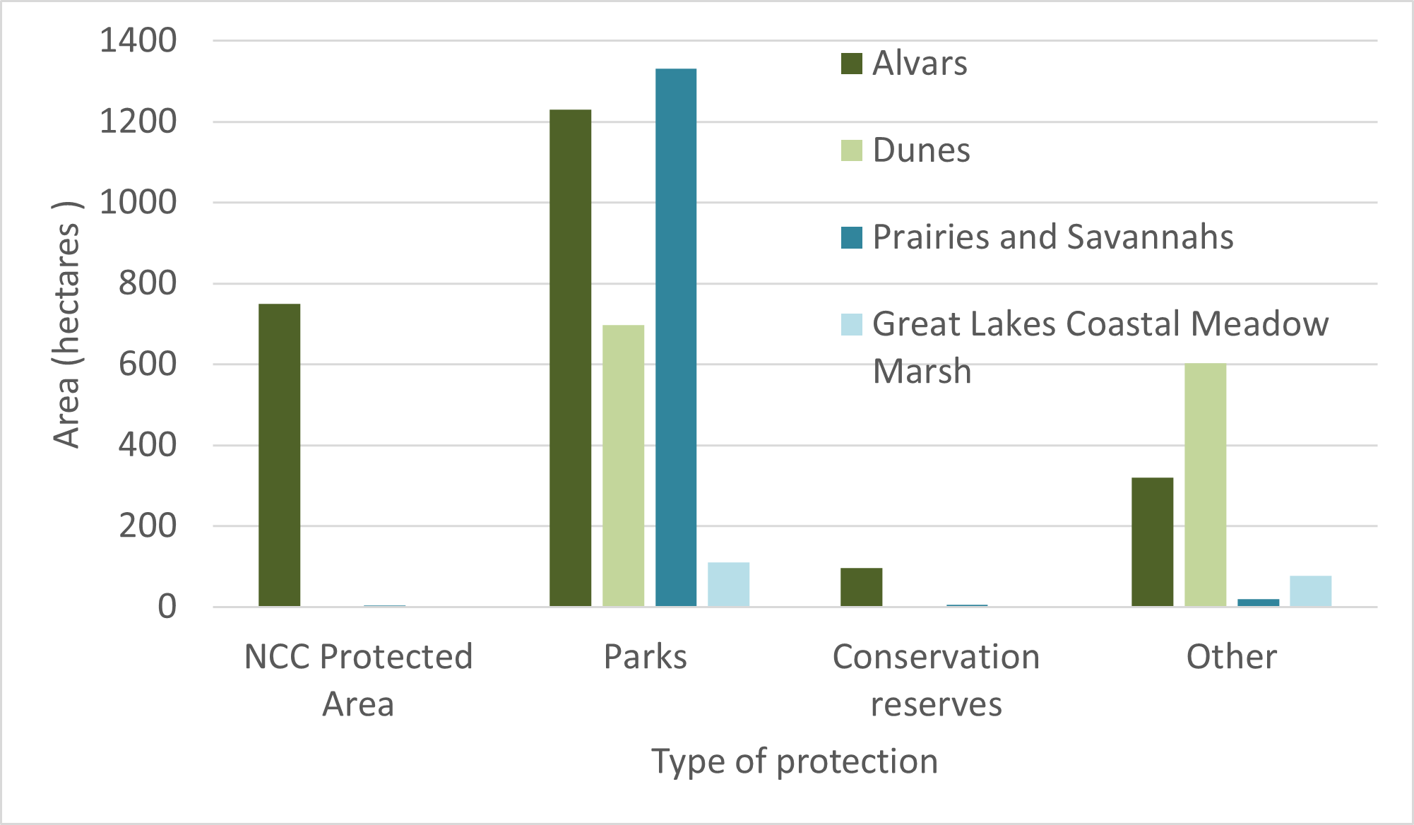
Figure 4. Area protected and types of protection in 2025 (source: NHIC database, MNR 2025).
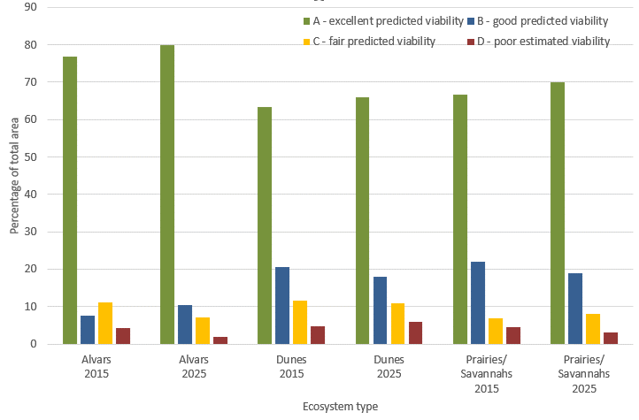
Figure 5. Proportion of area with quality ranks A-D in alvar, dune and prairie/savannah ecosystems in 2015 (13,420 ha), and 2025 (14,036 ha) (source: NHIC database, MNR 2025.)
Status
- Alvar ecosystems cover more area than the other rare ecosystem types with just over 10,000 ha across the province. In 2025 24% (2,397ha) of their total area is legally protected, this is a slight increase from 2021 (21%) and 2015 (14%). It is estimated that conservation lands not included in this analysis contribute to protecting an additional 10% of Ontario’s total alvar area.
- There are approximately 1,864 ha of freshwater coastal dune ecosystems in 2025, 70% (1303 ha) of which are protected, down from 80% (1506 ha) in 2021, and 75% (1320 ha) in 2015[1].
- In 2025, just more than half (57%) of the remaining prairie/savannah ecosystems are legally protected, this is down from 62% in 2021 and 61% in 2015[2].
- There are a total of 501 ha of Great Lakes Coastal Meadow Marshes in Ontario in 2025 and 37% of the area is protected. No trend is available for this ecosystem type as it was not included in previous assessments. All 501 ha of Great Lakes coast meadow marsh were assigned an excellent or good predicted viability ranking.
- In 2025 76% of occurrences of rare vegetation communities in all four ecosystem types were assigned an excellent or good predicted viability ranking, 17% were ranked as fair predicted viability and 7% were ranked as poor estimated viability.
- When looking only at the 3 ecosystem types that were assessed in previous SOBR reports (alvars, dunes and prairies/savannahs), 89% of the total area assessed in 2025 was assigned an excellent or good predicted viability ranking. This is the same as results from 2021 (89%) and a slight increase from 2015 (85%).
- The difference between the percent of high-quality rankings for number of occurrences vs. total area reflects the higher quality of larger areas and the consideration of size when assigning ranks.
[1] Some changes can be attributed to refinements to spatial extent of ecosystems based on new imagery, as well as new ecosystems being added to the database.
[2] Some changes can be attributed to refinements to spatial extent of ecosystems based on new imagery, as well as new ecosystems being added to the database
Previous versions
Ontario’s diverse ecosystems include some that are of conservation concern due to their limited distribution and high proportion of specialized species absent from most of the province. This includes prairies and savannahs (prairies with scattered trees), alvars (flat open limestone or dolostone habitats with thin soil), freshwater coastal dunes, and Great Lakes coastal meadow marshes (Figure 1). Although they are generally small in size, these rare habitats support many of Ontario’s globally and provincially rare flora and fauna. Conservation and restoration of these habitats can support the recovery of many species at risk through ecosystem-based approaches. As such, they are fundamentally important for the conservation of biodiversity in the province.
The extent of prairie and savannah ecosystems in Ontario has been greatly reduced. In the Mixedwood Plains Ecozone, only a fraction (2-3%) of these ecosystems remain (2,200 ha; Rodger 1998) and these are threatened by habitat loss, invasive alien species, and succession to forest due to fire suppression. Globally rare alvar communities occur only in a handful of scattered regions around the world, including the Great Lakes Basin of North America. Ontario contains 65-70% of the North American total, including sites on the Bruce Peninsula, Manitoulin and Pelee Island, and on the Napanee, Smith’s Falls and the Carden limestone plains. Alvar ecosystems in Ontario face similar threats as prairie and savannah habitats, but also conversion to quarries. Great Lakes sand dunes make up the world’s largest collection of freshwater coastal dunes (SOLEC 2009). Ranging from the high forested dunes and linear dune ridges commonly backing sand beaches, to active, moving dune fields, sand dunes can be found along the coasts of all the Great Lakes. Freshwater coastal dunes are fragile ecosystems that are easily affected by human activities. Great Lakes coastal meadow marshes are restricted to the near-shore areas of the Great Lakes (Lee et al. 1998) and are usually dominated by rushes and reeds. Great Lakes coastal meadow marshes support a number of plant species restricted to these shorelines, and they also provide habitat for diverse wildlife. These vital ecosystems are threatened by land conversion, pollution, invasive species, altered water levels and climate change.
The distribution and status of rare ecosystems is tracked by Ontario’s Natural Heritage Information Center based on plant communities (assemblages of plant species with a consistent composition, structure and habitat). To date, almost 1,700 occurrences of plant communities that are considered to be globally rare by NatureServe have been documented in Ontario (Figure 1). Sixty percent of these globally rare communities occur within the Mixedwood Plains Ecozone. There are other globally rare communities, including some wetland and talus ecosystems, as well as artic-alpine disjunct plants[1] that have been documented from Ontario not included in this indicator.
This indicator assesses the total area and quality of prairie, savannah, alvar, dune, and Great Lakes coastal meadow marsh ecosystems in Ontario, and the area of each that is protected in the province.
[1] arctic-alpine communities included in Figure 1, however extent not reviewed in this indicator.
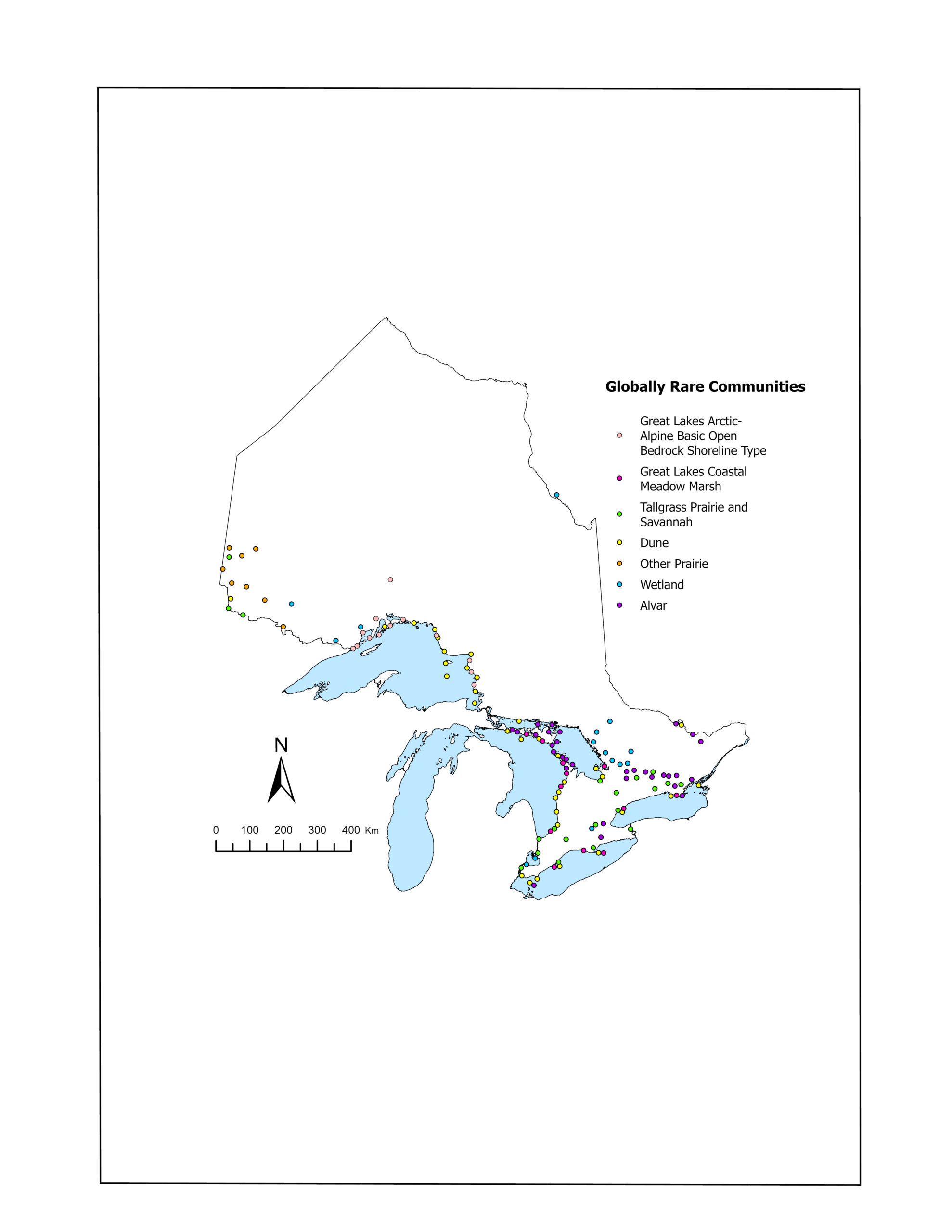
Figure 1. Distribution of globally rare plant communities in Ontario 2025.
Analysis for this indicator was based on detailed spatial data available through the Natural Heritage Information Centre. The areas of rare vegetation communities were summed to assess the total area of prairie and savannah, alvar, dune and Great Lakes coastal meadow marsh ecosystems in Ontario in 2025 (Figure 2). The boundaries of vegetation communities in these rare ecosystems was intersected with the boundaries of Provincial and National Parks, National Wildlife Areas, and Conservation Reserves using GIS to determine the proportion of each rare ecosystem type found in protected areas. Rare communities in protected areas are sometimes subjected to disturbance and threats from human use but are generally not subject to development and the same level of threats as non-protected areas.
The total area and proportion of protected area for alvar and freshwater coastal dune communities have been refined from data originally reported in the State of Ontario’s Biodiversity 2015 report based on new survey information and refined digitized polygons based on more recently available orthophotography. Prairie/savannah communities assessed in this indicator are limited to those on deep soils and the analysis does not currently include prairie communities on shallow soils that are found in Northwestern Ontario (‘Other Prairie’ category in Figure 1). Great Lakes coastal meadow marshes are included in the analysis for the first time in 2025.
In addition to the total area of protection, plant communities were assigned element occurrence quality ranks from A – D (Table 1) based on NatureServe data standards. Ranks were based on an examination of the size, condition, and landscape context of vegetation communities (Table 2). A full description of the ranking methodology can be found in Henson and Bakowsky (2014). For each rare ecosystem type, the total number and area of element occurrences assigned to each quality rank were tallied and plotted to compare changes between 2015 and 2025 (Figure 3).
It is important to note that the proportion of each rare ecosystem in protected areas is based on provincially and federally protected areas, as well as non-governmental protection areas such as conservation reserves and Ontario land trusts. Figure 4 includes areas protected and through which means in 2025. Conservation lands account for important additional protection for some rare ecosystems.
Table 1. Element occurrence quality ranks assigned to vegetation communities in Ontario’s prairie, savannah, alvar and dune ecosystems.
Quality rank
|
Description |
| A |
Excellent predicted viability |
| B |
Good predicted viability |
| C |
Fair predicted viability |
| D |
Poor estimated viability |
Table 2. Description of factors considered when assessing quality of vegetation community element occurrences (see Henson and Bakowsky 2014).
| Status |
Definition |
| Size |
Area of occupancy |
| Condition |
Development/maturity (stability, old-growth) |
| Ecological processes (degree of disturbance by logging, grazing, changes in hydrology or natural fire regime) |
| Abiotic physical/chemical factors (stability of substrate, physical structure, water quality) |
| Landscape context |
Landscape structure and extent (pattern, connectivity e.g., measure of fragmentation/patchiness, measure of genetic connectivity) |
| Condition of the surrounding landscape (i.e., Development/maturity, species composition and biological structure, ecological processes, abiotic physical/chemical factors) |
Related Theme(s)
Web Links:
Natural Heritage Information Centre https://www.ontario.ca/environment-and-energy/natural- heritage-information-centre
NatureServe Conservation Status Assessment https://www.natureserve.org/conservation-tools/conservation-status-assessment
Sask River Delta Conservation Initiative https://www.saskriverdelta.com/alvar
References:
Bakowsky, W.D., and B.L. Henson. 2014. Rare communities of Ontario: freshwater coastal dunes. Natural Heritage Information Centre, Ontario Ministry of Natural Resources, Queen’s Printer for Ontario, Peterborough, ON.
Brunton, D. F. and P.M. Catling. 2017. Thematic Collection: Alvars in Canada. Canadian Field Naturalist 131(1):75-79.
Henson, B.L., and W.D. Bakowsky. 2014. Plant community ranking methodology: alvars, dunes, prairies.
Natural Heritage Information Centre, Ontario Ministry of Natural Resources and Forestry, Peterborough, ON. [Available at: http://sobr.ca/_biosite/wp-content/uploads/Henson- and-Bakowsky-2014_Plant-Community-Ranking-Methodology-Alvars-Dunes-Prairies.pdf]
Lee, H.T., W.D. Bakowsky, J. Riley, J. Bowles, M. Puddister, P. Uhlig and S. McMurray. 1998. Ecological Land Classification for Southern Ontario: First Approximation and Its Application. Ontario Ministry of Natural Resources, Southcentral Science Section, Science Development and Transfer Branch. SCSS Field Guide FG-02.
Ontario Biodiversity Council. 2015. State of Ontario’s Biodiversity [web application]. Ontario Biodiversity Council, Peterborough, Ontario. [Available at: www.sobr.ca]
Ontario Biodiversity Council. 2021. State of Ontario’s Biodiversity 2020 Summary. Ontario Biodiversity Council, Peterborough, Ontario. [Available at: https://sobr.ca/report/]
Ontario Ministry of Natural Resources and Forestry. 2017. A Wetland Conservation Strategy for Ontario 2017–2030. Queen’s Printer for Ontario. Toronto, ON. 52 pp.
Rodger, L. 1998. Tallgrass communities of southern Ontario: A recovery plan. Report prepared for World Wildlife Fund Canada and the Ontario Ministry of Natural Resources.
State of the Lakes Ecosystem Conference (SOLEC). 2009. State of the Great Lakes 2009. Technical report prepared by Environment Canada and the United States Environmental Protection Agency. [Available at: http://www.epa.gov/solec/]
